Fuxin geodata
Fuxin (Liaoning) is a populated place; located in China in Asia/Shanghai (GMT+8) time zone. With population of 689,050 people, there are 91 cities with bigger population in this country. Compared to other cities in China, 91% of cities are located further ↓South; 90.5% of cities are located further ←West and 53.2% of cities have higher elevation than Fuxin. Note1


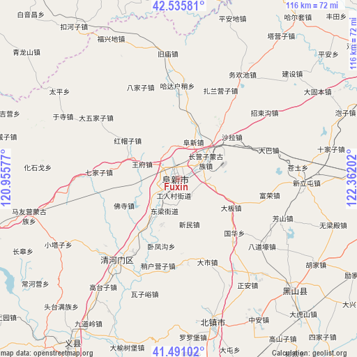
Fuxin GPS coordinates[2]
42° 0' 56.016" North, 121° 39' 32.004" East
| Map corner | latitude | longitude |
|---|---|---|
| Upper-left | 42.53581°, | 120.95577° |
| Center: | 42.01556°, | 121.65889° |
| Lower-right: | 41.49102°, | 122.36202° |
| Map W x H: | 116.2×116.2 km | = 72.2×72.2mi |
| max Lat: | 53.31946° ⇑9% North |
| Fuxin: | 42.01556° |
| min Lat: | ⇓91% South 18.22056° |
| min Long | Fuxin | max Long |
| 75.07348° | 121.65889° | 134.28917° |
| W 90.5%⇐ | ⇒9.5% E |
Elevation
Elevation of Fuxin is 142 m = 466 ft, and this is 342.8 m = 1125 ft below average elevation for this country.
| Max E: |
5622 m = 18445 ft | 53.2% |
| Avg. | 484.8 m = 1591 ft | |
| Fuxin | 142 m = 466 ft | |
Min E: |
-3 m = -10 ft | 46.8% |
See also: Fuxin elevation on elevation.city.
Geographical zone
Fuxin is located in North temperate zone (between Tropic of Cancer and the Arctic Circle). Distance of this Northern Tropic circle is 2065.8 km =1283.6 mi to South.| Distance of | km | miles | from Fuxin |
|---|---|---|---|
| North Pole | 5335.4 | 3315.3 | to North |
| Arctic Circle | 2729.5 | 1696 | to North |
| Tropic Cancer | 2065.8 | 1283.6 | to South |
| Equator | 4671.7 | 2902.9 | to South |


Nearby cities:
15 places around Fuxin: (largest is in red/bold)
• Baojia
57.5 km =35.7 mi,  175°
175°
• Beizhen
48 km =29.8 mi,  166°
166°
• Changxingdian
63.2 km =39.3 mi, 175°
• Dashi
28.4 km =17.6 mi,  161°
161°
• Futun
44.1 km =27.4 mi, 166°
• Gaoshanzi
61.3 km =38.1 mi,  148°
148°
• Heichengzi
58.1 km =36.1 mi,  283°
283°
• Heishan
52.3 km =32.5 mi,  133°
133°
• Liaotun
59.7 km =37.1 mi, 171°
• Luoluopu
51.6 km =32.1 mi, 174°
• Qingduizi
66.7 km =41.4 mi, 161°
• Taijiying
59.1 km =36.7 mi,  286°
286°
• Wujia
68 km =42.3 mi, 155°
• Zheng’an
41.3 km =25.7 mi, 146°
• Zhong’an
52.8 km =32.8 mi, 149°
Sources, notices
• [Note1] Compared only with cities in China existing in our database
• [Src1] Map data: © OpenStreetMap contributors (CC-BY-SA)
• [Src2] Other city data from geonames.org with taken over terms of usage.
• [Src3] Geographical zone / Annual Mean Temperature by Robert A. Rohde @ Wikipedia
