Dongxing geodata
Dongxing (Heilongjiang) is a seat of a fourth-order administrative division; located in China in Asia/Shanghai (GMT+8) time zone. In our database, there are 1268 cities with bigger population. Compared to other cities in China, 97.5% of cities are located further ↓South; 94.7% of cities are located further ←West and 50.4% of cities have higher elevation than Dongxing. Note1


Dongxing GPS coordinates[2]
47° 16' 3.9" North, 125° 1' 48.756" East
| Map corner | latitude | longitude |
|---|---|---|
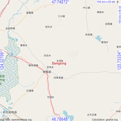
| Upper-left | 47.74272°, | 124.32709° |
| Center: | 47.26775°, | 125.03021° |
| Lower-right: | 46.78848°, | 125.73334° |
| Map W x H: | 106.1×106.1 km | = 65.9×65.9mi |
| max Lat: | 53.31946° ⇑2.5% North |
| Dongxing: | 47.26775° |
| min Lat: | ⇓97.5% South 18.22056° |
| min Long | Dongxing | max Long |
| 75.07348° | 125.03021° | 134.28917° |
| W 94.7%⇐ | ⇒5.3% E |
Elevation
Elevation of Dongxing is 161 m = 528 ft, and this is 323.8 m = 1062 ft below average elevation for this country.
| Max E: |
5622 m = 18445 ft | 50.4% |
| Avg. | 484.8 m = 1591 ft | |
| Dongxing | 161 m = 528 ft | |
Min E: |
-3 m = -10 ft | 49.6% |
See also: China elevation on elevation.city.
Geographical zone
Dongxing is located in North temperate zone (between Tropic of Cancer and the Arctic Circle). Distance of this North polar circle is 2145.5 km =1333.2 mi to North.| Distance of | km | miles | from Dongxing |
|---|---|---|---|
| North Pole | 4751.4 | 2952.4 | to North |
| Arctic Circle | 2145.5 | 1333.2 | to North |
| Tropic Cancer | 2649.8 | 1646.5 | to South |
| Equator | 5255.7 | 3265.7 | to South |


Nearby cities:
15 places around Dongxing: (largest is in red/bold)
• Chongde
42.5 km =26.4 mi,  88°
88°
• Fanrong
34.8 km =21.6 mi,  292°
292°
• Furao
42.1 km =26.2 mi,  67°
67°
• Hongqi
37.7 km =23.4 mi,  225°
225°
• Hongwei
10.4 km =6.5 mi,  238°
238°
• Huayuan
33.6 km =20.9 mi,  195°
195°
• Liming
15 km =9.3 mi,  186°
186°
• Lindian
15.5 km =9.6 mi, 232°
• Sanhe
24.4 km =15.2 mi,  260°
260°
• Sanxing
38.7 km =24 mi,  0°
0°
• Shaowen
31.3 km =19.4 mi,  341°
341°
• Sihe
12.5 km =7.8 mi, 290°
• Tongda
46.6 km =29 mi,  103°
103°
• Yilong
33.5 km =20.8 mi,  47°
47°
• Yulin
47.9 km =29.8 mi,  108°
108°
Sources, notices
• [Note1] Compared only with cities in China existing in our database
• [Src1] Map data: © OpenStreetMap contributors (CC-BY-SA)
• [Src2] Other city data from geonames.org with taken over terms of usage.
• [Src3] Geographical zone / Annual Mean Temperature by Robert A. Rohde @ Wikipedia
