Hongwei geodata
Hongwei (Heilongjiang) is a seat of a fourth-order administrative division; located in China in Asia/Shanghai (GMT+8) time zone. In our database, there are 1268 cities with bigger population. Compared to other cities in China, 97.4% of cities are located further ↓South; 94.7% of cities are located further ←West and 51.3% of cities have higher elevation than Hongwei. Note1


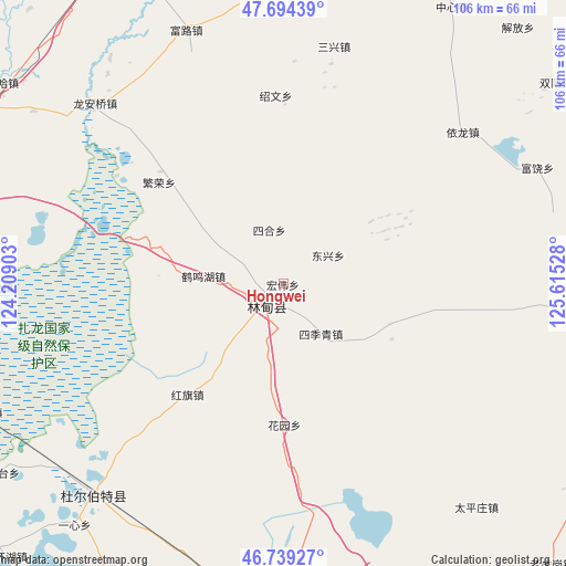
Hongwei GPS coordinates[2]
47° 13' 8.328" North, 124° 54' 43.74" East
| Map corner | latitude | longitude |
|---|---|---|
| Upper-left | 47.69439°, | 124.20903° |
| Center: | 47.21898°, | 124.91215° |
| Lower-right: | 46.73927°, | 125.61528° |
| Map W x H: | 106.2×106.2 km | = 66×66mi |
| max Lat: | 53.31946° ⇑2.6% North |
| Hongwei: | 47.21898° |
| min Lat: | ⇓97.4% South 18.22056° |
| min Long | Hongwei | max Long |
| 75.07348° | 124.91215° | 134.28917° |
| W 94.7%⇐ | ⇒5.3% E |
Elevation
Elevation of Hongwei is 154 m = 505 ft, and this is 330.8 m = 1085 ft below average elevation for this country.
| Max E: |
5622 m = 18445 ft | 51.3% |
| Avg. | 484.8 m = 1591 ft | |
| Hongwei | 154 m = 505 ft | |
Min E: |
-3 m = -10 ft | 48.7% |
See also: China elevation on elevation.city.
Geographical zone
Hongwei is located in North temperate zone (between Tropic of Cancer and the Arctic Circle). Distance of this North polar circle is 2150.9 km =1336.5 mi to North.| Distance of | km | miles | from Hongwei |
|---|---|---|---|
| North Pole | 4756.8 | 2955.7 | to North |
| Arctic Circle | 2150.9 | 1336.5 | to North |
| Tropic Cancer | 2644.3 | 1643.1 | to South |
| Equator | 5250.3 | 3262.4 | to South |


Nearby cities:
15 places around Hongwei: (largest is in red/bold)
• Chongde
51.8 km =32.2 mi,  82°
82°
• Dongxing
10.4 km =6.5 mi,  58°
58°
• Fanrong
29.9 km =18.6 mi,  308°
308°
• Fulu
50.4 km =31.3 mi,  339°
339°
• Furao
52.4 km =32.6 mi,  65°
65°
• Hongqi
27.6 km =17.1 mi,  220°
220°
• Huayuan
26.9 km =16.7 mi,  180°
180°
• Liming
11.9 km =7.4 mi,  142°
142°
• Lindian
5.3 km =3.3 mi, 219°
• Long’anqiao
48.5 km =30.1 mi, 313°
• Sanhe
15.2 km =9.4 mi,  274°
274°
• Sanxing
45.1 km =28 mi,  11°
11°
• Shaowen
35.1 km =21.8 mi,  358°
358°
• Sihe
10.3 km =6.4 mi, 344°
• Yilong
43.8 km =27.2 mi,  50°
50°
Sources, notices
• [Note1] Compared only with cities in China existing in our database
• [Src1] Map data: © OpenStreetMap contributors (CC-BY-SA)
• [Src2] Other city data from geonames.org with taken over terms of usage.
• [Src3] Geographical zone / Annual Mean Temperature by Robert A. Rohde @ Wikipedia
