Lindian geodata
Lindian (Heilongjiang) is a seat of a third-order administrative division; located in China in Asia/Shanghai (GMT+8) time zone. In our database, there are 1268 cities with bigger population. Compared to other cities in China, 97.3% of cities are located further ↓South; 94.6% of cities are located further ←West and 51.2% of cities have higher elevation than Lindian. Note1


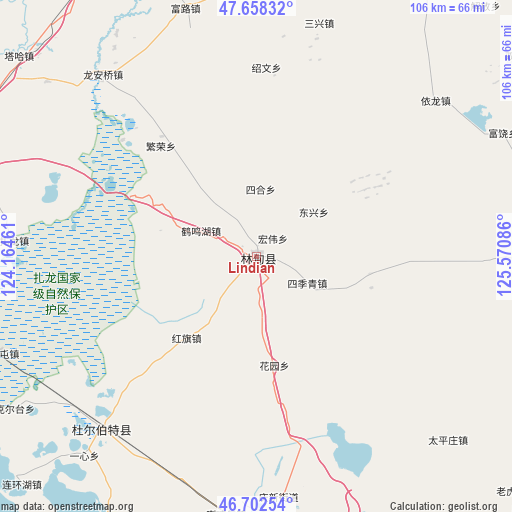
Lindian GPS coordinates[2]
47° 10' 57.288" North, 124° 52' 3.828" East
| Map corner | latitude | longitude |
|---|---|---|
| Upper-left | 47.65832°, | 124.16461° |
| Center: | 47.18258°, | 124.86773° |
| Lower-right: | 46.70254°, | 125.57086° |
| Map W x H: | 106.3×106.3 km | = 66.1×66.1mi |
| max Lat: | 53.31946° ⇑2.7% North |
| Lindian: | 47.18258° |
| min Lat: | ⇓97.3% South 18.22056° |
| min Long | Lindian | max Long |
| 75.07348° | 124.86773° | 134.28917° |
| W 94.6%⇐ | ⇒5.4% E |
Elevation
Elevation of Lindian is 155 m = 509 ft, and this is 329.8 m = 1082 ft below average elevation for this country.
| Max E: |
5622 m = 18445 ft | 51.2% |
| Avg. | 484.8 m = 1591 ft | |
| Lindian | 155 m = 509 ft | |
Min E: |
-3 m = -10 ft | 48.8% |
See also: China elevation on elevation.city.
Geographical zone
Lindian is located in North temperate zone (between Tropic of Cancer and the Arctic Circle). Distance of this North polar circle is 2155 km =1339.1 mi to North.| Distance of | km | miles | from Lindian |
|---|---|---|---|
| North Pole | 4760.9 | 2958.3 | to North |
| Arctic Circle | 2155 | 1339.1 | to North |
| Tropic Cancer | 2640.3 | 1640.6 | to South |
| Equator | 5246.2 | 3259.8 | to South |


Nearby cities:
15 places around Lindian: (largest is in red/bold)
• Dongxing
15.5 km =9.6 mi,  52°
52°
• Fanrong
30.3 km =18.8 mi,  318°
318°
• Fulu
53.2 km =33.1 mi,  344°
344°
• Hongqi
22.3 km =13.9 mi,  221°
221°
• Hongwei
5.3 km =3.3 mi,  39°
39°
• Huayuan
23.1 km =14.4 mi,  171°
171°
• Liming
11.8 km =7.3 mi,  117°
117°
• Long’anqiao
49.1 km =30.5 mi, 319°
• Sanhe
13 km =8.1 mi,  294°
294°
• Sanxing
49.8 km =30.9 mi,  14°
14°
• Shaowen
39.2 km =24.4 mi,  3°
3°
• Sihe
13.9 km =8.6 mi, 2°
• Taikang
48.1 km =29.9 mi, 222°
• Yilong
49 km =30.4 mi, 49°
• Zhalong
50.5 km =31.4 mi,  273°
273°
Sources, notices
• [Note1] Compared only with cities in China existing in our database
• [Src1] Map data: © OpenStreetMap contributors (CC-BY-SA)
• [Src2] Other city data from geonames.org with taken over terms of usage.
• [Src3] Geographical zone / Annual Mean Temperature by Robert A. Rohde @ Wikipedia
