Shaowen geodata
Shaowen (Heilongjiang) is a seat of a fourth-order administrative division; located in China in Asia/Shanghai (GMT+8) time zone. In our database, there are 1268 cities with bigger population. Compared to other cities in China, 98% of cities are located further ↓South; 94.7% of cities are located further ←West and 50.3% of cities have higher elevation than Shaowen. Note1


Shaowen GPS coordinates[2]
47° 32' 4.38" North, 124° 53' 47.868" East
| Map corner | latitude | longitude |
|---|---|---|
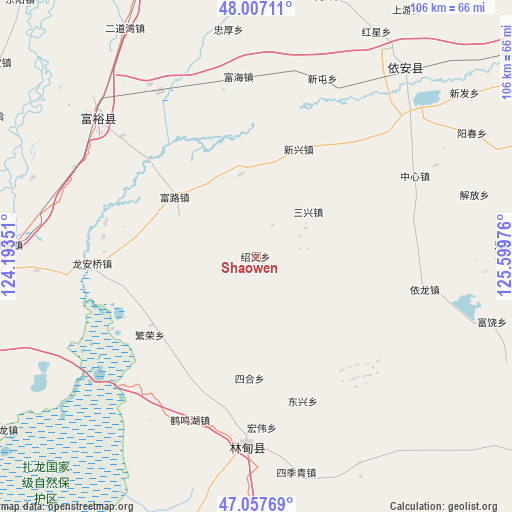
| Upper-left | 48.00711°, | 124.19351° |
| Center: | 47.53455°, | 124.89663° |
| Lower-right: | 47.05769°, | 125.59976° |
| Map W x H: | 105.6×105.6 km | = 65.6×65.6mi |
| max Lat: | 53.31946° ⇑2% North |
| Shaowen: | 47.53455° |
| min Lat: | ⇓98% South 18.22056° |
| min Long | Shaowen | max Long |
| 75.07348° | 124.89663° | 134.28917° |
| W 94.7%⇐ | ⇒5.3% E |
Elevation
Elevation of Shaowen is 162 m = 531 ft, and this is 322.8 m = 1059 ft below average elevation for this country.
| Max E: |
5622 m = 18445 ft | 50.3% |
| Avg. | 484.8 m = 1591 ft | |
| Shaowen | 162 m = 531 ft | |
Min E: |
-3 m = -10 ft | 49.7% |
See also: China elevation on elevation.city.
Geographical zone
Shaowen is located in North temperate zone (between Tropic of Cancer and the Arctic Circle). Distance of this North polar circle is 2115.8 km =1314.7 mi to North.| Distance of | km | miles | from Shaowen |
|---|---|---|---|
| North Pole | 4721.7 | 2933.9 | to North |
| Arctic Circle | 2115.8 | 1314.7 | to North |
| Tropic Cancer | 2679.4 | 1664.9 | to South |
| Equator | 5285.3 | 3284.1 | to South |


Nearby cities:
15 places around Shaowen: (largest is in red/bold)
• Dongxing
31.3 km =19.4 mi,  161°
161°
• Fanrong
27.4 km =17 mi,  233°
233°
• Fuhai
37.4 km =23.2 mi,  355°
355°
• Fulu
20.4 km =12.7 mi,  306°
306°
• Fuyu
44 km =27.3 mi, 311°
• Hongwei
35.1 km =21.8 mi,  178°
178°
• Lindian
39.2 km =24.4 mi, 183°
• Long’anqiao
34 km =21.1 mi,  267°
267°
• Sanhe
36.5 km =22.7 mi,  202°
202°
• Sanxing
13.8 km =8.6 mi,  49°
49°
• Sihe
25.3 km =15.7 mi, 183°
• Xintun
36.5 km =22.7 mi,  19°
19°
• Xinxing
23.9 km =14.9 mi, 21°
• Yilong
35.4 km =22 mi,  101°
101°
• Zhongxin
36.5 km =22.7 mi,  62°
62°
Sources, notices
• [Note1] Compared only with cities in China existing in our database
• [Src1] Map data: © OpenStreetMap contributors (CC-BY-SA)
• [Src2] Other city data from geonames.org with taken over terms of usage.
• [Src3] Geographical zone / Annual Mean Temperature by Robert A. Rohde @ Wikipedia
