Hailun geodata
Hailun (Heilongjiang) is a seat of a third-order administrative division; located in China in Asia/Shanghai (GMT+8) time zone. With population of 109,881 people, there are 396 cities with bigger population in this country. Compared to other cities in China, 97.8% of cities are located further ↓South; 96.6% of cities are located further ←West and 58.6% of cities have lower elevation than Hailun. Note1


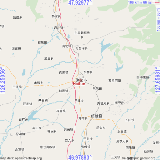
Hailun GPS coordinates[2]
47° 27' 23.4" North, 126° 57' 13.248" East
| Map corner | latitude | longitude |
|---|---|---|
| Upper-left | 47.92977°, | 126.25056° |
| Center: | 47.4565°, | 126.95368° |
| Lower-right: | 46.97893°, | 127.65681° |
| Map W x H: | 105.7×105.7 km | = 65.7×65.7mi |
| max Lat: | 53.31946° ⇑2.2% North |
| Hailun: | 47.4565° |
| min Lat: | ⇓97.8% South 18.22056° |
| min Long | Hailun | max Long |
| 75.07348° | 126.95368° | 134.28917° |
| W 96.6%⇐ | ⇒3.4% E |
Elevation
Elevation of Hailun is 242 m = 794 ft, and this is 242.8 m = 797 ft below average elevation for this country.
| Max E: |
5622 m = 18445 ft | 41.4% |
| Avg. | 484.8 m = 1591 ft | |
| Hailun | 242 m = 794 ft | |
Min E: |
-3 m = -10 ft | 58.6% |
See also: Hailun elevation on elevation.city.
Geographical zone
Hailun is located in North temperate zone (between Tropic of Cancer and the Arctic Circle). Distance of this North polar circle is 2124.5 km =1320.1 mi to North.| Distance of | km | miles | from Hailun |
|---|---|---|---|
| North Pole | 4730.4 | 2939.3 | to North |
| Arctic Circle | 2124.5 | 1320.1 | to North |
| Tropic Cancer | 2670.7 | 1659.5 | to South |
| Equator | 5276.7 | 3278.8 | to South |


Nearby cities:
15 places around Hailun: (largest is in red/bold)
• Aimin
25.2 km =15.7 mi,  305°
305°
• Changfa
8 km =5 mi,  349°
349°
• Dongfeng
12.5 km =7.8 mi,  114°
114°
• Donglin
7.3 km =4.5 mi,  42°
42°
• Haibei
24.1 km =15 mi,  339°
339°
• Hainan
25 km =15.5 mi,  175°
175°
• Keyinhe
22.1 km =13.7 mi,  133°
133°
• Leye
18.3 km =11.4 mi, 181°
• Qianjin
12.5 km =7.8 mi,  238°
238°
• Shuangchahe
23.2 km =14.4 mi,  89°
89°
• Shuanglu
20.7 km =12.9 mi,  19°
19°
• Suileng
25.5 km =15.8 mi,  155°
155°
• Xiangfu
23.9 km =14.9 mi,  212°
212°
• Xiangrong
12.1 km =7.5 mi,  300°
300°
• Yonghe
27.4 km =17 mi,  267°
267°
Sources, notices
• [Note1] Compared only with cities in China existing in our database
• [Src1] Map data: © OpenStreetMap contributors (CC-BY-SA)
• [Src2] Other city data from geonames.org with taken over terms of usage.
• [Src3] Geographical zone / Annual Mean Temperature by Robert A. Rohde @ Wikipedia
