Dashitou geodata
Dashitou (Jilin) is a populated place; located in China in Asia/Shanghai (GMT+8) time zone. With population of 65,683 people, there are 659 cities with bigger population in this country. Compared to other cities in China, 92.2% of cities are located further ↓South; 98.2% of cities are located further ←West and 75.1% of cities have lower elevation than Dashitou. Note1


Dashitou GPS coordinates[2]
43° 18' 24.012" North, 128° 30' 41.004" East
| Map corner | latitude | longitude |
|---|---|---|
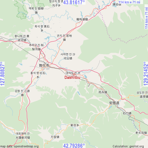
| Upper-left | 43.81617°, | 127.80827° |
| Center: | 43.30667°, | 128.51139° |
| Lower-right: | 42.79286°, | 129.21452° |
| Map W x H: | 113.8×113.8 km | = 70.7×70.7mi |
| max Lat: | 53.31946° ⇑7.8% North |
| Dashitou: | 43.30667° |
| min Lat: | ⇓92.2% South 18.22056° |
| min Long | Dashitou | max Long |
| 75.07348° | 128.51139° | 134.28917° |
| W 98.2%⇐ | ⇒1.8% E |
Elevation
Elevation of Dashitou is 524 m = 1719 ft, and this is 39.2 m = 129 ft above average elevation for this country.
| Max E: |
5622 m = 18445 ft | 24.9% |
| Dashitou | 524 m 1719 ft | |
| Avg. | 484.8 m = 1591 ft | |
Min E: |
-3 m = -10 ft | 75.1% |
See also: Dashitou elevation on elevation.city.
Geographical zone
Dashitou is located in North temperate zone (between Tropic of Cancer and the Arctic Circle). Distance of this Northern Tropic circle is 2209.3 km =1372.8 mi to South.| Distance of | km | miles | from Dashitou |
|---|---|---|---|
| North Pole | 5191.8 | 3226 | to North |
| Arctic Circle | 2585.9 | 1606.8 | to North |
| Tropic Cancer | 2209.3 | 1372.8 | to South |
| Equator | 4815.3 | 2992.1 | to South |


Nearby cities:
15 places around Dashitou: (largest is in red/bold)
• Changxing
37.2 km =23.1 mi,  111°
111°
• Dadianzi
50.5 km =31.4 mi,  197°
197°
• Dapuchaihe
61.5 km =38.2 mi,  219°
219°
• Dashahe
68.2 km =42.4 mi, 197°
• Dongjiang
80.4 km =50 mi, 204°
• Dunhua
22.9 km =14.2 mi,  288°
288°
• Huangnihe
48.3 km =30 mi,  305°
305°
• Liangbing
25.9 km =16.1 mi,  121°
121°
• Mingyue
40 km =24.9 mi, 123°
• Sandaowan
56 km =34.8 mi, 106°
• Shimen
51 km =31.7 mi,  126°
126°
• Shiqi
39 km =24.2 mi,  178°
178°
• Tongfosi
75.5 km =46.9 mi, 128°
• Xiaoshahe
76.3 km =47.4 mi,  193°
193°
• Xilinhe
74.1 km =46 mi, 134°
Sources, notices
• [Note1] Compared only with cities in China existing in our database
• [Src1] Map data: © OpenStreetMap contributors (CC-BY-SA)
• [Src2] Other city data from geonames.org with taken over terms of usage.
• [Src3] Geographical zone / Annual Mean Temperature by Robert A. Rohde @ Wikipedia
