Changtu geodata
Changtu (Liaoning) is a seat of a third-order administrative division; located in China in Asia/Shanghai (GMT+8) time zone. With population of 71,284 people, there are 600 cities with bigger population in this country. Compared to other cities in China, 91.7% of cities are located further ↓South; 93.9% of cities are located further ←West and 54.4% of cities have higher elevation than Changtu. Note1


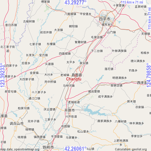
Changtu GPS coordinates[2]
42° 46' 43.824" North, 124° 5' 43.62" East
| Map corner | latitude | longitude |
|---|---|---|
| Upper-left | 43.29277°, | 123.39233° |
| Center: | 42.77884°, | 124.09545° |
| Lower-right: | 42.26061°, | 124.79858° |
| Map W x H: | 114.8×114.8 km | = 71.3×71.3mi |
| max Lat: | 53.31946° ⇑8.3% North |
| Changtu: | 42.77884° |
| min Lat: | ⇓91.7% South 18.22056° |
| min Long | Changtu | max Long |
| 75.07348° | 124.09545° | 134.28917° |
| W 93.9%⇐ | ⇒6.1% E |
Elevation
Elevation of Changtu is 135 m = 443 ft, and this is 349.8 m = 1148 ft below average elevation for this country.
| Max E: |
5622 m = 18445 ft | 54.4% |
| Avg. | 484.8 m = 1591 ft | |
| Changtu | 135 m = 443 ft | |
Min E: |
-3 m = -10 ft | 45.6% |
See also: Changtu elevation on elevation.city.
Geographical zone
Changtu is located in North temperate zone (between Tropic of Cancer and the Arctic Circle). Distance of this Northern Tropic circle is 2150.6 km =1336.3 mi to South.| Distance of | km | miles | from Changtu |
|---|---|---|---|
| North Pole | 5250.5 | 3262.5 | to North |
| Arctic Circle | 2644.6 | 1643.3 | to North |
| Tropic Cancer | 2150.6 | 1336.3 | to South |
| Equator | 4756.6 | 2955.6 | to South |


Nearby cities:
15 places around Changtu: (largest is in red/bold)
• Bamiancheng
46.7 km =29 mi,  355°
355°
• Dasijiazi
37.5 km =23.3 mi,  266°
266°
• Daxing
20.5 km =12.7 mi, 272°
• Ertaizi
11.1 km =6.9 mi,  341°
341°
• Guyushu
36.2 km =22.5 mi,  242°
242°
• Jinjia
32 km =19.9 mi, 274°
• Kaiyuan
27.7 km =17.2 mi,  189°
189°
• Laocheng
8.3 km =5.2 mi, 273°
• Maojiadian
33.4 km =20.8 mi,  28°
28°
• Mazhonghe
9.3 km =5.8 mi,  219°
219°
• Qiujia
37.7 km =23.4 mi, 357°
• Quantou
11.4 km =7.1 mi, 32°
• Shibajiazi
30.3 km =18.8 mi,  246°
246°
• Xia’ertai
24.8 km =15.4 mi,  40°
40°
• Yongfeng
20.5 km =12.7 mi,  258°
258°
Sources, notices
• [Note1] Compared only with cities in China existing in our database
• [Src1] Map data: © OpenStreetMap contributors (CC-BY-SA)
• [Src2] Other city data from geonames.org with taken over terms of usage.
• [Src3] Geographical zone / Annual Mean Temperature by Robert A. Rohde @ Wikipedia
