Quantou geodata
Quantou (Liaoning) is a seat of a fourth-order administrative division; located in China in Asia/Shanghai (GMT+8) time zone. In our database, there are 1268 cities with bigger population. Compared to other cities in China, 91.8% of cities are located further ↓South; 94% of cities are located further ←West and 51.4% of cities have lower elevation than Quantou. Note1


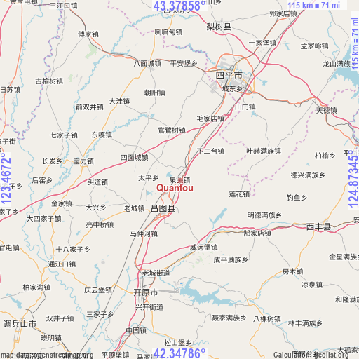
Quantou GPS coordinates[2]
42° 51' 55.332" North, 124° 10' 13.152" East
| Map corner | latitude | longitude |
|---|---|---|
| Upper-left | 43.37858°, | 123.4672° |
| Center: | 42.86537°, | 124.17032° |
| Lower-right: | 42.34786°, | 124.87345° |
| Map W x H: | 114.6×114.6 km | = 71.2×71.2mi |
| max Lat: | 53.31946° ⇑8.2% North |
| Quantou: | 42.86537° |
| min Lat: | ⇓91.8% South 18.22056° |
| min Long | Quantou | max Long |
| 75.07348° | 124.17032° | 134.28917° |
| W 94%⇐ | ⇒6% E |
Elevation
Elevation of Quantou is 176 m = 577 ft, and this is 308.8 m = 1013 ft below average elevation for this country.
| Max E: |
5622 m = 18445 ft | 48.6% |
| Avg. | 484.8 m = 1591 ft | |
| Quantou | 176 m = 577 ft | |
Min E: |
-3 m = -10 ft | 51.4% |
See also: China elevation on elevation.city.
Geographical zone
Quantou is located in North temperate zone (between Tropic of Cancer and the Arctic Circle). Distance of this Northern Tropic circle is 2160.3 km =1342.3 mi to South.| Distance of | km | miles | from Quantou |
|---|---|---|---|
| North Pole | 5240.9 | 3256.5 | to North |
| Arctic Circle | 2635 | 1637.3 | to North |
| Tropic Cancer | 2160.3 | 1342.3 | to South |
| Equator | 4766.2 | 2961.6 | to South |


Nearby cities:
15 places around Quantou: (largest is in red/bold)
• Bamiancheng
38.2 km =23.7 mi,  345°
345°
• Changtu
11.4 km =7.1 mi,  212°
212°
• Daxing
27.9 km =17.3 mi,  252°
252°
• Ertaizi
9.7 km =6 mi,  275°
275°
• Jinjia
38.6 km =24 mi,  259°
259°
• Kaiyuan
38.4 km =23.9 mi,  196°
196°
• Laocheng
17 km =10.6 mi,  237°
237°
• Maojiadian
22 km =13.7 mi,  26°
26°
• Mazhonghe
20.6 km =12.8 mi,  215°
215°
• Qiujia
29.1 km =18.1 mi,  344°
344°
• Quangou
36 km =22.4 mi,  11°
11°
• Shibajiazi
40.3 km =25 mi, 237°
• Siping
37 km =23 mi, 27°
• Xia’ertai
13.6 km =8.5 mi,  46°
46°
• Yongfeng
29.6 km =18.4 mi, 242°
Sources, notices
• [Note1] Compared only with cities in China existing in our database
• [Src1] Map data: © OpenStreetMap contributors (CC-BY-SA)
• [Src2] Other city data from geonames.org with taken over terms of usage.
• [Src3] Geographical zone / Annual Mean Temperature by Robert A. Rohde @ Wikipedia
