Bamiancheng geodata
Bamiancheng (Liaoning) is a seat of a fourth-order administrative division; located in China in Asia/Shanghai (GMT+8) time zone. In our database, there are 1268 cities with bigger population. Compared to other cities in China, 92.1% of cities are located further ↓South; 93.8% of cities are located further ←West and 53.8% of cities have higher elevation than Bamiancheng. Note1


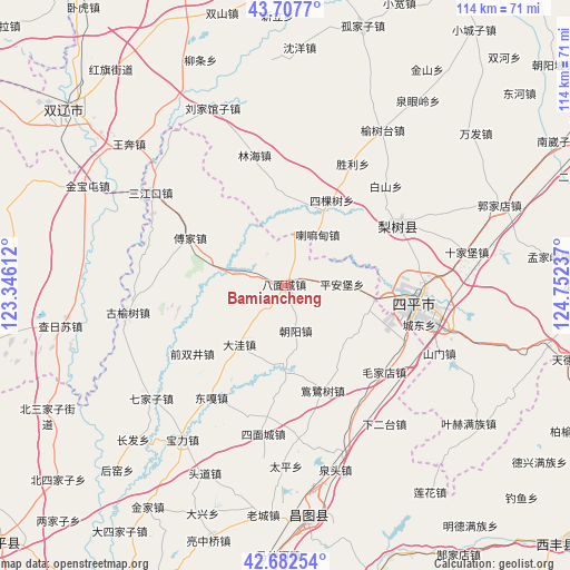
Bamiancheng GPS coordinates[2]
43° 11' 50.172" North, 124° 2' 57.264" East
| Map corner | latitude | longitude |
|---|---|---|
| Upper-left | 43.7077°, | 123.34612° |
| Center: | 43.19727°, | 124.04924° |
| Lower-right: | 42.68254°, | 124.75237° |
| Map W x H: | 114×114 km | = 70.8×70.8mi |
| max Lat: | 53.31946° ⇑7.9% North |
| Bamiancheng: | 43.19727° |
| min Lat: | ⇓92.1% South 18.22056° |
| min Long | Bamiancheng | max Long |
| 75.07348° | 124.04924° | 134.28917° |
| W 93.8%⇐ | ⇒6.2% E |
Elevation
Elevation of Bamiancheng is 138 m = 453 ft, and this is 346.8 m = 1138 ft below average elevation for this country.
| Max E: |
5622 m = 18445 ft | 53.8% |
| Avg. | 484.8 m = 1591 ft | |
| Bamiancheng | 138 m = 453 ft | |
Min E: |
-3 m = -10 ft | 46.2% |
See also: China elevation on elevation.city.
Geographical zone
Bamiancheng is located in North temperate zone (between Tropic of Cancer and the Arctic Circle). Distance of this Northern Tropic circle is 2197.2 km =1365.3 mi to South.| Distance of | km | miles | from Bamiancheng |
|---|---|---|---|
| North Pole | 5204 | 3233.6 | to North |
| Arctic Circle | 2598.1 | 1614.4 | to North |
| Tropic Cancer | 2197.2 | 1365.3 | to South |
| Equator | 4803.1 | 2984.5 | to South |


Nearby cities:
15 places around Bamiancheng: (largest is in red/bold)
• Changtu
46.7 km =29 mi,  175°
175°
• Daxing
48.5 km =30.1 mi,  200°
200°
• Ertaizi
36 km =22.4 mi, 179°
• Fujia
21.5 km =13.4 mi,  296°
296°
• Jinjia
52.2 km =32.4 mi,  212°
212°
• Laocheng
46.2 km =28.7 mi,  185°
185°
• Laowobao
51.3 km =31.9 mi,  234°
234°
• Lishu
25.5 km =15.8 mi,  62°
62°
• Maojiadian
26.3 km =16.3 mi,  131°
131°
• Qiujia
9.1 km =5.7 mi,  167°
167°
• Quangou
17.3 km =10.7 mi,  95°
95°
• Quantou
38.2 km =23.7 mi, 165°
• Qujiadian
10.1 km =6.3 mi,  285°
285°
• Siping
26.9 km =16.7 mi, 98°
• Xia’ertai
33.9 km =21.1 mi,  144°
144°
Sources, notices
• [Note1] Compared only with cities in China existing in our database
• [Src1] Map data: © OpenStreetMap contributors (CC-BY-SA)
• [Src2] Other city data from geonames.org with taken over terms of usage.
• [Src3] Geographical zone / Annual Mean Temperature by Robert A. Rohde @ Wikipedia
