Shengli geodata
Shengli (Inner Mongolia) is a seat of a fourth-order administrative division; located in China in Asia/Shanghai (GMT+8) time zone. In our database, there are 1268 cities with bigger population. Compared to other cities in China, 89.5% of cities are located further ↓South; 58.3% of cities are located further →East and 93.1% of cities have lower elevation than Shengli. Note1


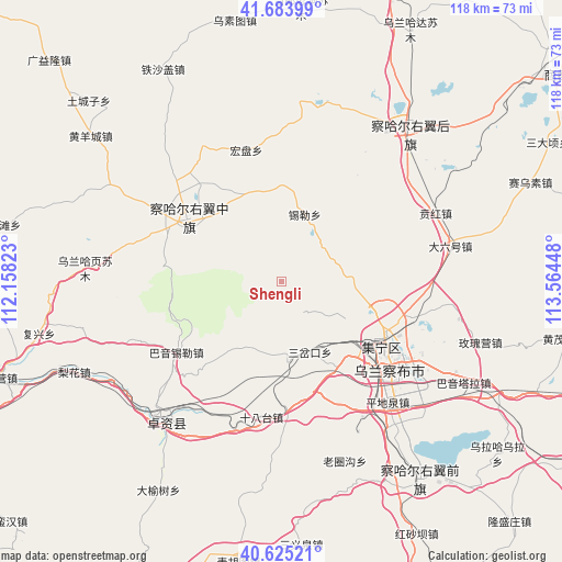
Shengli GPS coordinates[2]
41° 9' 24.264" North, 112° 51' 40.86" East
| Map corner | latitude | longitude |
|---|---|---|
| Upper-left | 41.68399°, | 112.15823° |
| Center: | 41.15674°, | 112.86135° |
| Lower-right: | 40.62521°, | 113.56448° |
| Map W x H: | 117.7×117.7 km | = 73.1×73.1mi |
| max Lat: | 53.31946° ⇑10.5% North |
| Shengli: | 41.15674° |
| min Lat: | ⇓89.5% South 18.22056° |
| min Long | Shengli | max Long |
| 75.07348° | 112.86135° | 134.28917° |
| W 41.7%⇐ | ⇒58.3% E |
Elevation
Elevation of Shengli is 1722 m = 5650 ft, and this is 1237.2 m = 4059 ft above average elevation for this country.
| Max E: |
5622 m = 18445 ft | 6.9% |
| Shengli | 1722 m 5650 ft | |
| Avg. | 484.8 m = 1591 ft | |
Min E: |
-3 m = -10 ft | 93.1% |
See also: China elevation on elevation.city.
Geographical zone
Shengli is located in North temperate zone (between Tropic of Cancer and the Arctic Circle). Distance of this Northern Tropic circle is 1970.3 km =1224.3 mi to South.| Distance of | km | miles | from Shengli |
|---|---|---|---|
| North Pole | 5430.9 | 3374.6 | to North |
| Arctic Circle | 2825 | 1755.4 | to North |
| Tropic Cancer | 1970.3 | 1224.3 | to South |
| Equator | 4576.2 | 2843.5 | to South |


Nearby cities:
15 places around Shengli: (largest is in red/bold)
• Benhong
35.3 km =21.9 mi,  64°
64°
• Daliuhao
36.7 km =22.8 mi,  77°
77°
• Erhaodi
36.8 km =22.9 mi,  292°
292°
• Hobor
23.4 km =14.5 mi,  303°
303°
• Hongpan
28.5 km =17.7 mi,  345°
345°
• Jining
25 km =15.5 mi,  125°
125°
• Jinpen
34.7 km =21.6 mi,  248°
248°
• Miliangju
39.3 km =24.4 mi, 300°
• Qisumu
32.8 km =20.4 mi,  283°
283°
• Sandaogou
30.4 km =18.9 mi,  324°
324°
• Shiyaogou
22.8 km =14.2 mi,  50°
50°
• Wulan Haye
40.7 km =25.3 mi,  273°
273°
• Xilei
15 km =9.3 mi,  19°
19°
• Yuanshanzi
20 km =12.4 mi, 322°
• Zhuozishan
38.2 km =23.7 mi,  221°
221°
Sources, notices
• [Note1] Compared only with cities in China existing in our database
• [Src1] Map data: © OpenStreetMap contributors (CC-BY-SA)
• [Src2] Other city data from geonames.org with taken over terms of usage.
• [Src3] Geographical zone / Annual Mean Temperature by Robert A. Rohde @ Wikipedia
