Lishu geodata
Lishu (Jilin) is a seat of a third-order administrative division; located in China in Asia/Shanghai (GMT+8) time zone. With population of 61,584 people, there are 707 cities with bigger population in this country. Compared to other cities in China, 92.2% of cities are located further ↓South; 94.2% of cities are located further ←West and 50.4% of cities have lower elevation than Lishu. Note1


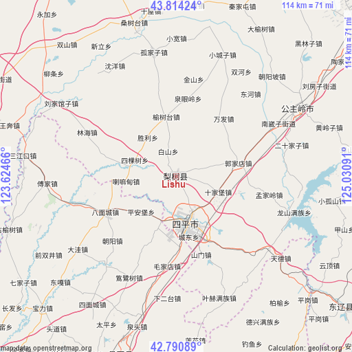
Lishu GPS coordinates[2]
43° 18' 16.992" North, 124° 19' 40.008" East
| Map corner | latitude | longitude |
|---|---|---|
| Upper-left | 43.81424°, | 123.62466° |
| Center: | 43.30472°, | 124.32778° |
| Lower-right: | 42.79089°, | 125.03091° |
| Map W x H: | 113.8×113.8 km | = 70.7×70.7mi |
| max Lat: | 53.31946° ⇑7.8% North |
| Lishu: | 43.30472° |
| min Lat: | ⇓92.2% South 18.22056° |
| min Long | Lishu | max Long |
| 75.07348° | 124.32778° | 134.28917° |
| W 94.2%⇐ | ⇒5.8% E |
Elevation
Elevation of Lishu is 168 m = 551 ft, and this is 316.8 m = 1039 ft below average elevation for this country.
| Max E: |
5622 m = 18445 ft | 49.6% |
| Avg. | 484.8 m = 1591 ft | |
| Lishu | 168 m = 551 ft | |
Min E: |
-3 m = -10 ft | 50.4% |
See also: Lishu elevation on elevation.city.
Geographical zone
Lishu is located in North temperate zone (between Tropic of Cancer and the Arctic Circle). Distance of this Northern Tropic circle is 2209.1 km =1372.7 mi to South.| Distance of | km | miles | from Lishu |
|---|---|---|---|
| North Pole | 5192 | 3226.2 | to North |
| Arctic Circle | 2586.1 | 1606.9 | to North |
| Tropic Cancer | 2209.1 | 1372.7 | to South |
| Equator | 4815 | 2991.9 | to South |


Nearby cities:
15 places around Lishu: (largest is in red/bold)
• Baiquan
69.2 km =43 mi,  132°
132°
• Bamiancheng
25.5 km =15.8 mi,  242°
242°
• Changtu
61.4 km =38.2 mi,  197°
197°
• Daxing
69.6 km =43.2 mi,  214°
214°
• Ertaizi
52.9 km =32.9 mi, 205°
• Fujia
41.9 km =26 mi,  266°
266°
• Gongzhuling
45.3 km =28.1 mi,  61°
61°
• Laocheng
64 km =39.8 mi, 205°
• Maojiadian
29.3 km =18.2 mi,  185°
185°
• Qiujia
29.4 km =18.3 mi,  224°
224°
• Quangou
14.7 km =9.1 mi, 201°
• Quantou
50.5 km =31.4 mi, 194°
• Qujiadian
33.5 km =20.8 mi,  254°
254°
• Siping
16.4 km =10.2 mi,  165°
165°
• Xia’ertai
39.6 km =24.6 mi,  184°
184°
Sources, notices
• [Note1] Compared only with cities in China existing in our database
• [Src1] Map data: © OpenStreetMap contributors (CC-BY-SA)
• [Src2] Other city data from geonames.org with taken over terms of usage.
• [Src3] Geographical zone / Annual Mean Temperature by Robert A. Rohde @ Wikipedia
