Bangshipu geodata
Bangshipu (Liaoning) is a seat of a fourth-order administrative division; located in China in Asia/Shanghai (GMT+8) time zone. In our database, there are 1268 cities with bigger population. Compared to other cities in China, 87.9% of cities are located further ↓South; 92.3% of cities are located further ←West and 63.9% of cities have higher elevation than Bangshipu. Note1


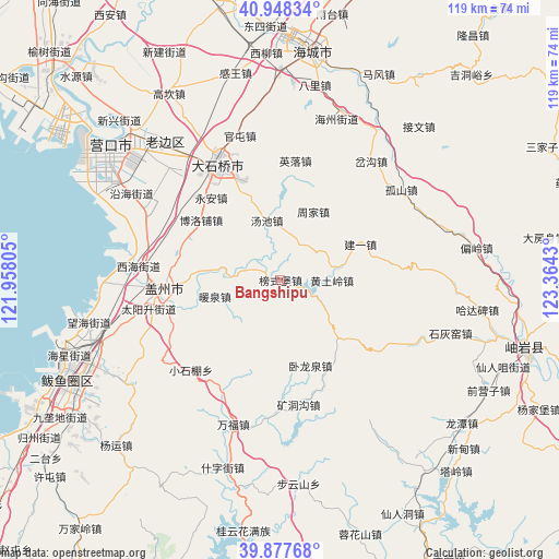
Bangshipu GPS coordinates[2]
40° 24' 54.504" North, 122° 39' 40.212" East
| Map corner | latitude | longitude |
|---|---|---|
| Upper-left | 40.94834°, | 121.95805° |
| Center: | 40.41514°, | 122.66117° |
| Lower-right: | 39.87768°, | 123.3643° |
| Map W x H: | 119×119 km | = 73.9×73.9mi |
| max Lat: | 53.31946° ⇑12.1% North |
| Bangshipu: | 40.41514° |
| min Lat: | ⇓87.9% South 18.22056° |
| min Long | Bangshipu | max Long |
| 75.07348° | 122.66117° | 134.28917° |
| W 92.3%⇐ | ⇒7.7% E |
Elevation
Elevation of Bangshipu is 78 m = 256 ft, and this is 406.8 m = 1335 ft below average elevation for this country.
| Max E: |
5622 m = 18445 ft | 63.9% |
| Avg. | 484.8 m = 1591 ft | |
| Bangshipu | 78 m = 256 ft | |
Min E: |
-3 m = -10 ft | 36.1% |
See also: China elevation on elevation.city.
Geographical zone
Bangshipu is located in North temperate zone (between Tropic of Cancer and the Arctic Circle). Distance of this Northern Tropic circle is 1887.8 km =1173 mi to South.| Distance of | km | miles | from Bangshipu |
|---|---|---|---|
| North Pole | 5513.3 | 3425.8 | to North |
| Arctic Circle | 2907.4 | 1806.6 | to North |
| Tropic Cancer | 1887.8 | 1173 | to South |
| Equator | 4493.7 | 2792.3 | to South |


Nearby cities:
15 places around Bangshipu: (largest is in red/bold)
• Boluopu
21.3 km =13.2 mi,  306°
306°
• Dongcheng
24.5 km =15.2 mi,  267°
267°
• Gaotun
5.4 km =3.4 mi,  293°
293°
• Huangtuling
11 km =6.8 mi,  91°
91°
• Jianyi
18.7 km =11.6 mi,  66°
66°
• Lüwang
18 km =11.2 mi,  95°
95°
• Nuanquan
13.9 km =8.6 mi,  254°
254°
• Qingshiling
22 km =13.7 mi, 287°
• Tangchi
13.2 km =8.2 mi,  345°
345°
• Tuandian
16.5 km =10.3 mi,  276°
276°
• Weiziyu
9.3 km =5.8 mi,  36°
36°
• Wolongquan
18.5 km =11.5 mi,  160°
160°
• Xutun
24.4 km =15.2 mi, 251°
• Yong’an
22.5 km =14 mi,  320°
320°
• Zhoujia
16 km =9.9 mi,  26°
26°
Sources, notices
• [Note1] Compared only with cities in China existing in our database
• [Src1] Map data: © OpenStreetMap contributors (CC-BY-SA)
• [Src2] Other city data from geonames.org with taken over terms of usage.
• [Src3] Geographical zone / Annual Mean Temperature by Robert A. Rohde @ Wikipedia
