Wolongquan geodata
Wolongquan (Liaoning) is a seat of a fourth-order administrative division; located in China in Asia/Shanghai (GMT+8) time zone. In our database, there are 1268 cities with bigger population. Compared to other cities in China, 87.4% of cities are located further ↓South; 92.4% of cities are located further ←West and 62.8% of cities have lower elevation than Wolongquan. Note1


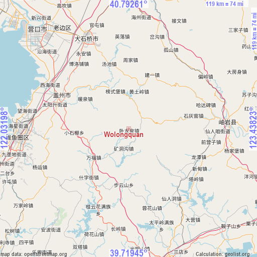
Wolongquan GPS coordinates[2]
40° 15' 29.376" North, 122° 44' 6.36" East
| Map corner | latitude | longitude |
|---|---|---|
| Upper-left | 40.79261°, | 122.03198° |
| Center: | 40.25816°, | 122.7351° |
| Lower-right: | 39.71945°, | 123.43823° |
| Map W x H: | 119.3×119.3 km | = 74.1×74.1mi |
| max Lat: | 53.31946° ⇑12.6% North |
| Wolongquan: | 40.25816° |
| min Lat: | ⇓87.4% South 18.22056° |
| min Long | Wolongquan | max Long |
| 75.07348° | 122.7351° | 134.28917° |
| W 92.4%⇐ | ⇒7.6% E |
Elevation
Elevation of Wolongquan is 293 m = 961 ft, and this is 191.8 m = 629 ft below average elevation for this country.
| Max E: |
5622 m = 18445 ft | 37.2% |
| Avg. | 484.8 m = 1591 ft | |
| Wolongquan | 293 m = 961 ft | |
Min E: |
-3 m = -10 ft | 62.8% |
See also: China elevation on elevation.city.
Geographical zone
Wolongquan is located in North temperate zone (between Tropic of Cancer and the Arctic Circle). Distance of this Northern Tropic circle is 1870.4 km =1162.2 mi to South.| Distance of | km | miles | from Wolongquan |
|---|---|---|---|
| North Pole | 5530.8 | 3436.7 | to North |
| Arctic Circle | 2924.9 | 1817.4 | to North |
| Tropic Cancer | 1870.4 | 1162.2 | to South |
| Equator | 4476.3 | 2781.4 | to South |


Nearby cities:
15 places around Wolongquan: (largest is in red/bold)
• Bangshipu
18.5 km =11.5 mi,  340°
340°
• Buyunshan
26.3 km =16.3 mi,  185°
185°
• Gaotun
22.5 km =14 mi,  330°
330°
• Huangtuling
17.9 km =11.1 mi,  15°
15°
• Jianyi
27.2 km =16.9 mi, 23°
• Kuangdonggou
9.8 km =6.1 mi,  195°
195°
• Liangtun
19.1 km =11.9 mi,  254°
254°
• Lüwang
19.6 km =12.2 mi,  36°
36°
• Nuanquan
24 km =14.9 mi,  304°
304°
• Shizijie
30.2 km =18.8 mi,  223°
223°
• Taipingzhuang
11.7 km =7.3 mi,  147°
147°
• Tuandian
29.9 km =18.6 mi,  310°
310°
• Wanfu
20.8 km =12.9 mi,  230°
230°
• Weiziyu
24.9 km =15.5 mi,  358°
358°
• Yangshufang
25.7 km =16 mi,  266°
266°
Sources, notices
• [Note1] Compared only with cities in China existing in our database
• [Src1] Map data: © OpenStreetMap contributors (CC-BY-SA)
• [Src2] Other city data from geonames.org with taken over terms of usage.
• [Src3] Geographical zone / Annual Mean Temperature by Robert A. Rohde @ Wikipedia
