Laojiangjunjie geodata
Laojiangjunjie (Yunnan) is a seat of a fourth-order administrative division; located in China in Asia/Shanghai (GMT+8) time zone. In our database, there are 1268 cities with bigger population. Compared to other cities in China, 87.7% of cities are located further ↑North; 92% of cities are located further →East and 94.4% of cities have lower elevation than Laojiangjunjie. Note1


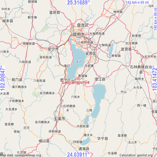
Laojiangjunjie GPS coordinates[2]
24° 40' 46.704" North, 102° 42' 41.724" East
| Map corner | latitude | longitude |
|---|---|---|
| Upper-left | 25.31689°, | 102.00847° |
| Center: | 24.67964°, | 102.71159° |
| Lower-right: | 24.03911°, | 103.41472° |
| Map W x H: | 142.1×142.1 km | = 88.3×88.3mi |
| max Lat: | 53.31946° ⇑87.7% North |
| Laojiangjunjie: | 24.67964° |
| min Lat: | ⇓12.3% South 18.22056° |
| min Long | Laojiangjunjie | max Long |
| 75.07348° | 102.71159° | 134.28917° |
| W 8%⇐ | ⇒92% E |
Elevation
Elevation of Laojiangjunjie is 1914 m = 6280 ft, and this is 1429.2 m = 4689 ft above average elevation for this country.
| Max E: |
5622 m = 18445 ft | 5.6% |
| Laojiangjunjie | 1914 m 6280 ft | |
| Avg. | 484.8 m = 1591 ft | |
Min E: |
-3 m = -10 ft | 94.4% |
See also: China elevation on elevation.city.
Geographical zone
Laojiangjunjie is located in North temperate zone (between Tropic of Cancer and the Arctic Circle). Distance of this Northern Tropic circle is 138.2 km =85.9 mi to South.| Distance of | km | miles | from Laojiangjunjie |
|---|---|---|---|
| North Pole | 7262.9 | 4513 | to North |
| Arctic Circle | 4657.1 | 2893.8 | to North |
| Tropic Cancer | 138.2 | 85.9 | to South |
| Equator | 2744.1 | 1705.1 | to South |


Nearby cities:
15 places around Laojiangjunjie: (largest is in red/bold)
• Fenglu
20.2 km =12.6 mi,  90°
90°
• Haikou
17.7 km =11 mi,  309°
309°
• Huacheng
15.4 km =9.6 mi,  38°
38°
• Huayue
7.7 km =4.8 mi,  147°
147°
• Huichang
13.6 km =8.5 mi,  299°
299°
• Jincheng
4.1 km =2.5 mi,  52°
52°
• Kunyang
12.2 km =7.6 mi,  263°
263°
• Liujie
16.1 km =10 mi,  189°
189°
• Longcheng
25.9 km =16.1 mi,  20°
20°
• Longjie
18.5 km =11.5 mi,  100°
100°
• Shangfang Xinjie
21.3 km =13.2 mi,  229°
229°
• Taipingguan
18.6 km =11.6 mi,  25°
25°
• Wujiaying
25.6 km =15.9 mi, 31°
• Xiaojie
22.6 km =14 mi, 100°
• Xinjie
7.3 km =4.5 mi,  7°
7°
Sources, notices
• [Note1] Compared only with cities in China existing in our database
• [Src1] Map data: © OpenStreetMap contributors (CC-BY-SA)
• [Src2] Other city data from geonames.org with taken over terms of usage.
• [Src3] Geographical zone / Annual Mean Temperature by Robert A. Rohde @ Wikipedia
