Haikou geodata
Haikou (Yunnan) is a seat of a fourth-order administrative division; located in China in Asia/Shanghai (GMT+8) time zone. With population of 112,644 people, there are 386 cities with bigger population in this country. Compared to other cities in China, 87.3% of cities are located further ↑North; 92.2% of cities are located further →East and 94.3% of cities have lower elevation than Haikou. Note1


Haikou GPS coordinates[2]
24° 46' 47.46" North, 102° 34' 31.728" East
| Map corner | latitude | longitude |
|---|---|---|
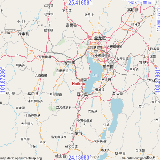
| Upper-left | 25.41658°, | 101.87236° |
| Center: | 24.77985°, | 102.57548° |
| Lower-right: | 24.13983°, | 103.27861° |
| Map W x H: | 142×142 km | = 88.2×88.2mi |
| max Lat: | 53.31946° ⇑87.3% North |
| Haikou: | 24.77985° |
| min Lat: | ⇓12.7% South 18.22056° |
| min Long | Haikou | max Long |
| 75.07348° | 102.57548° | 134.28917° |
| W 7.8%⇐ | ⇒92.2% E |
Elevation
Elevation of Haikou is 1909 m = 6263 ft, and this is 1424.2 m = 4673 ft above average elevation for this country.
| Max E: |
5622 m = 18445 ft | 5.7% |
| Haikou | 1909 m 6263 ft | |
| Avg. | 484.8 m = 1591 ft | |
Min E: |
-3 m = -10 ft | 94.3% |
See also: Haikou elevation on elevation.city.
Geographical zone
Haikou is located in North temperate zone (between Tropic of Cancer and the Arctic Circle). Distance of this Northern Tropic circle is 149.3 km =92.8 mi to South.| Distance of | km | miles | from Haikou |
|---|---|---|---|
| North Pole | 7251.8 | 4506.1 | to North |
| Arctic Circle | 4645.9 | 2886.8 | to North |
| Tropic Cancer | 149.3 | 92.8 | to South |
| Equator | 2755.3 | 1712.1 | to South |


Nearby cities:
15 places around Haikou: (largest is in red/bold)
• Bajie
24.9 km =15.5 mi,  240°
240°
• Gaoyao
23.4 km =14.5 mi,  11°
11°
• Huacheng
23.3 km =14.5 mi,  87°
87°
• Huayue
25.1 km =15.6 mi,  134°
134°
• Huichang
4.8 km =3 mi,  155°
155°
• Jincheng
19.1 km =11.9 mi,  116°
116°
• Kunyang
12.6 km =7.8 mi,  172°
172°
• Laojiangjunjie
17.7 km =11 mi, 129°
• Lianran
18.3 km =11.4 mi,  330°
330°
• Liujia
24.9 km =15.5 mi,  34°
34°
• Mingyihe
14.9 km =9.3 mi,  273°
273°
• Taiping
19.2 km =11.9 mi,  3°
3°
• Taipingguan
22.5 km =14 mi,  75°
75°
• Xianjie
17.7 km =11 mi,  299°
299°
• Xinjie
15.2 km =9.4 mi,  104°
104°
Sources, notices
• [Note1] Compared only with cities in China existing in our database
• [Src1] Map data: © OpenStreetMap contributors (CC-BY-SA)
• [Src2] Other city data from geonames.org with taken over terms of usage.
• [Src3] Geographical zone / Annual Mean Temperature by Robert A. Rohde @ Wikipedia
