Wangcungang geodata
Wangcungang (Guangdong) is a seat of a fourth-order administrative division; located in China in Asia/Urumqi (GMT+6) time zone. In our database, there are 1268 cities with bigger population. Compared to other cities in China, 98.2% of cities are located further ↑North; 67.2% of cities are located further →East and 84.9% of cities have higher elevation than Wangcungang. Note1


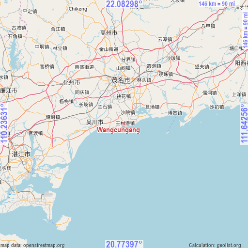
Wangcungang GPS coordinates[2]
21° 25' 47.784" North, 110° 56' 21.948" East
| Map corner | latitude | longitude |
|---|---|---|
| Upper-left | 22.08298°, | 110.23631° |
| Center: | 21.42994°, | 110.93943° |
| Lower-right: | 20.77397°, | 111.64256° |
| Map W x H: | 145.5×145.5 km | = 90.4×90.4mi |
| max Lat: | 53.31946° ⇑98.2% North |
| Wangcungang: | 21.42994° |
| min Lat: | ⇓1.8% South 18.22056° |
| min Long | Wangcungang | max Long |
| 75.07348° | 110.93943° | 134.28917° |
| W 32.8%⇐ | ⇒67.2% E |
Elevation
Elevation of Wangcungang is 16 m = 52 ft, and this is 468.8 m = 1538 ft below average elevation for this country.
| Max E: |
5622 m = 18445 ft | 84.9% |
| Avg. | 484.8 m = 1591 ft | |
| Wangcungang | 16 m = 52 ft | |
Min E: |
-3 m = -10 ft | 15.1% |
See also: China elevation on elevation.city.
Geographical zone
Wangcungang is located in North Torrid zone (between Equator and Tropic of Cancer). Distance of this Northern Tropic circle is 223.1 km =138.6 mi to North.| Distance of | km | miles | from Wangcungang |
|---|---|---|---|
| North Pole | 7624.3 | 4737.5 | to North |
| Arctic Circle | 5018.4 | 3118.3 | to North |
| Tropic Cancer | 223.1 | 138.6 | to North |
| Equator | 2382.8 | 1480.6 | to South |


Nearby cities:
15 places around Wangcungang: (largest is in red/bold)
• Aotou
16.1 km =10 mi,  328°
328°
• Bopu
15.2 km =9.4 mi,  278°
278°
• Dashanjiang
14.7 km =9.1 mi,  269°
269°
• Gaodi
8.9 km =5.5 mi,  31°
31°
• Haibin
16.5 km =10.3 mi,  257°
257°
• Lanshi
15.1 km =9.4 mi,  309°
309°
• Meihua
16.5 km =10.3 mi,  358°
358°
• Meilu
17 km =10.6 mi, 271°
• Nanhai
10.2 km =6.3 mi,  62°
62°
• Qijing
16.4 km =10.2 mi,  20°
20°
• Shayuan
4.8 km =3 mi,  66°
66°
• Shuidong
11.3 km =7 mi, 34°
• Tanba
8.9 km =5.5 mi, 281°
• Wuchuan
18.2 km =11.3 mi, 279°
• Xiaoliang
8.6 km =5.3 mi,  324°
324°
Sources, notices
• [Note1] Compared only with cities in China existing in our database
• [Src1] Map data: © OpenStreetMap contributors (CC-BY-SA)
• [Src2] Other city data from geonames.org with taken over terms of usage.
• [Src3] Geographical zone / Annual Mean Temperature by Robert A. Rohde @ Wikipedia
