Huhe geodata
Huhe (Anhui) is a seat of a fourth-order administrative division; located in China in Asia/Shanghai (GMT+8) time zone. In our database, there are 1268 cities with bigger population. Compared to other cities in China, 58.5% of cities are located further ↓South; 73.8% of cities are located further ←West and 85.5% of cities have higher elevation than Huhe. Note1


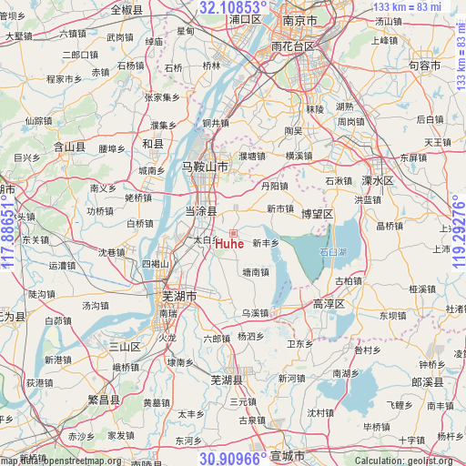
Huhe GPS coordinates[2]
31° 30' 39.672" North, 118° 35' 22.668" East
| Map corner | latitude | longitude |
|---|---|---|
| Upper-left | 32.10853°, | 117.88651° |
| Center: | 31.51102°, | 118.58963° |
| Lower-right: | 30.90966°, | 119.29276° |
| Map W x H: | 133.3×133.3 km | = 82.8×82.8mi |
| max Lat: | 53.31946° ⇑41.5% North |
| Huhe: | 31.51102° |
| min Lat: | ⇓58.5% South 18.22056° |
| min Long | Huhe | max Long |
| 75.07348° | 118.58963° | 134.28917° |
| W 73.8%⇐ | ⇒26.2% E |
Elevation
Elevation of Huhe is 15 m = 49 ft, and this is 469.8 m = 1541 ft below average elevation for this country.
| Max E: |
5622 m = 18445 ft | 85.5% |
| Avg. | 484.8 m = 1591 ft | |
| Huhe | 15 m = 49 ft | |
Min E: |
-3 m = -10 ft | 14.5% |
See also: China elevation on elevation.city.
Geographical zone
Huhe is located in North temperate zone (between Tropic of Cancer and the Arctic Circle). Distance of this Northern Tropic circle is 897.8 km =557.9 mi to South.| Distance of | km | miles | from Huhe |
|---|---|---|---|
| North Pole | 6503.4 | 4041 | to North |
| Arctic Circle | 3897.5 | 2421.8 | to North |
| Tropic Cancer | 897.8 | 557.9 | to South |
| Equator | 3503.7 | 2177.1 | to South |


Nearby cities:
15 places around Huhe: (largest is in red/bold)
• Dalong
14.6 km =9.1 mi,  126°
126°
• Dazha
16.3 km =10.1 mi,  205°
205°
• Dongjiang Matoukou
16.1 km =10 mi,  306°
306°
• Gushu
11.6 km =7.2 mi,  298°
298°
• Longshanqiao
10.3 km =6.4 mi,  260°
260°
• Maqiao
11.5 km =7.1 mi,  173°
173°
• Niandou
15.1 km =9.4 mi,  235°
235°
• Shiqiao
7.7 km =4.8 mi, 172°
• Taibai
7.6 km =4.7 mi, 259°
• Tangnan
12.6 km =7.8 mi,  148°
148°
• Xinfeng
9.7 km =6 mi,  104°
104°
• Xinqiao
13.1 km =8.1 mi,  270°
270°
• Xinshi
15.4 km =9.6 mi,  61°
61°
• Xuejin
8.8 km =5.5 mi,  34°
34°
• Yintang
11.6 km =7.2 mi,  330°
330°
Sources, notices
• [Note1] Compared only with cities in China existing in our database
• [Src1] Map data: © OpenStreetMap contributors (CC-BY-SA)
• [Src2] Other city data from geonames.org with taken over terms of usage.
• [Src3] Geographical zone / Annual Mean Temperature by Robert A. Rohde @ Wikipedia
