Yuezhao geodata
Yuezhao (Gansu) is a seat of a fourth-order administrative division; located in China in Asia/Shanghai (GMT+8) time zone. In our database, there are 1268 cities with bigger population. Compared to other cities in China, 66.8% of cities are located further ↓South; 88.8% of cities are located further →East and 93.2% of cities have lower elevation than Yuezhao. Note1


Yuezhao GPS coordinates[2]
33° 8' 26.124" North, 105° 9' 39.888" East
| Map corner | latitude | longitude |
|---|---|---|
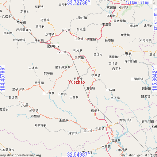
| Upper-left | 33.72736°, | 104.45796° |
| Center: | 33.14059°, | 105.16108° |
| Lower-right: | 32.54987°, | 105.86421° |
| Map W x H: | 130.9×130.9 km | = 81.3×81.3mi |
| max Lat: | 53.31946° ⇑33.2% North |
| Yuezhao: | 33.14059° |
| min Lat: | ⇓66.8% South 18.22056° |
| min Long | Yuezhao | max Long |
| 75.07348° | 105.16108° | 134.28917° |
| W 11.2%⇐ | ⇒88.8% E |
Elevation
Elevation of Yuezhao is 1733 m = 5686 ft, and this is 1248.2 m = 4095 ft above average elevation for this country.
| Max E: |
5622 m = 18445 ft | 6.8% |
| Yuezhao | 1733 m 5686 ft | |
| Avg. | 484.8 m = 1591 ft | |
Min E: |
-3 m = -10 ft | 93.2% |
See also: China elevation on elevation.city.
Geographical zone
Yuezhao is located in North temperate zone (between Tropic of Cancer and the Arctic Circle). Distance of this Northern Tropic circle is 1079 km =670.5 mi to South.| Distance of | km | miles | from Yuezhao |
|---|---|---|---|
| North Pole | 6322.2 | 3928.4 | to North |
| Arctic Circle | 3716.3 | 2309.2 | to North |
| Tropic Cancer | 1079 | 670.5 | to South |
| Equator | 3684.9 | 2289.7 | to South |


Nearby cities:
15 places around Yuezhao: (largest is in red/bold)
• Guohe
23.4 km =14.5 mi,  357°
357°
• Jiegan
17.6 km =10.9 mi,  339°
339°
• Luotang
12.6 km =7.8 mi,  129°
129°
• Moba
16.5 km =10.3 mi,  306°
306°
• Pandi
14 km =8.7 mi,  171°
171°
• Pipa
14.5 km =9 mi,  78°
78°
• Sancang
14.7 km =9.1 mi,  196°
196°
• Sanhe
17.7 km =11 mi,  1°
1°
• Sheshu
22 km =13.7 mi,  287°
287°
• Toufang
13.4 km =8.3 mi,  334°
334°
• Waina
12.7 km =7.9 mi, 305°
• Weihe
22.2 km =13.8 mi,  136°
136°
• Wuku
18.5 km =11.5 mi,  227°
227°
• Xizhi
19.5 km =12.1 mi,  111°
111°
• Yuhuang
17.9 km =11.1 mi,  19°
19°
Sources, notices
• [Note1] Compared only with cities in China existing in our database
• [Src1] Map data: © OpenStreetMap contributors (CC-BY-SA)
• [Src2] Other city data from geonames.org with taken over terms of usage.
• [Src3] Geographical zone / Annual Mean Temperature by Robert A. Rohde @ Wikipedia
