Zhaoren geodata
Zhaoren (Shaanxi) is a seat of a third-order administrative division; located in China in Asia/Shanghai (GMT+8) time zone. In our database, there are 1268 cities with bigger population. Compared to other cities in China, 75.4% of cities are located further ↓South; 81.3% of cities are located further →East and 88.1% of cities have lower elevation than Zhaoren. Note1


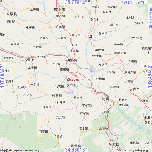
Zhaoren GPS coordinates[2]
35° 12' 24.012" North, 107° 47' 29.004" East
| Map corner | latitude | longitude |
|---|---|---|
| Upper-left | 35.77914°, | 107.08827° |
| Center: | 35.20667°, | 107.79139° |
| Lower-right: | 34.63013°, | 108.49452° |
| Map W x H: | 127.8×127.8 km | = 79.4×79.4mi |
| max Lat: | 53.31946° ⇑24.6% North |
| Zhaoren: | 35.20667° |
| min Lat: | ⇓75.4% South 18.22056° |
| min Long | Zhaoren | max Long |
| 75.07348° | 107.79139° | 134.28917° |
| W 18.7%⇐ | ⇒81.3% E |
Elevation
Elevation of Zhaoren is 1196 m = 3924 ft, and this is 711.2 m = 2333 ft above average elevation for this country.
| Max E: |
5622 m = 18445 ft | 11.9% |
| Zhaoren | 1196 m 3924 ft | |
| Avg. | 484.8 m = 1591 ft | |
Min E: |
-3 m = -10 ft | 88.1% |
See also: China elevation on elevation.city.
Geographical zone
Zhaoren is located in North temperate zone (between Tropic of Cancer and the Arctic Circle). Distance of this Northern Tropic circle is 1308.7 km =813.2 mi to South.| Distance of | km | miles | from Zhaoren |
|---|---|---|---|
| North Pole | 6092.4 | 3785.6 | to North |
| Arctic Circle | 3486.6 | 2166.5 | to North |
| Tropic Cancer | 1308.7 | 813.2 | to South |
| Equator | 3914.6 | 2432.4 | to South |


Nearby cities:
15 places around Zhaoren: (largest is in red/bold)
• Chejiazhuang
26.1 km =16.2 mi,  157°
157°
• Cuimu
44.4 km =27.6 mi,  171°
171°
• Didian
34.4 km =21.4 mi,  154°
154°
• Hanjia
31.7 km =19.7 mi, 167°
• Hexi
29.1 km =18.1 mi,  179°
179°
• Jingchuan Chengguanzhen
41.5 km =25.8 mi,  289°
289°
• Pingyao
45.3 km =28.1 mi, 158°
• Puwo
35.7 km =22.2 mi,  223°
223°
• Shaozhai
24 km =14.9 mi, 177°
• Shuikou
32.2 km =20 mi,  144°
144°
• Taiyu
39 km =24.2 mi, 141°
• Tiantang
38.7 km =24 mi,  214°
214°
• Xinbuzi
36.4 km =22.6 mi,  132°
132°
• Xinning
34.1 km =21.2 mi,  20°
20°
• Zhangba
36.9 km =22.9 mi,  200°
200°
Sources, notices
• [Note1] Compared only with cities in China existing in our database
• [Src1] Map data: © OpenStreetMap contributors (CC-BY-SA)
• [Src2] Other city data from geonames.org with taken over terms of usage.
• [Src3] Geographical zone / Annual Mean Temperature by Robert A. Rohde @ Wikipedia
