Taiping geodata
Taiping (Shaanxi) is a seat of a fourth-order administrative division; located in China in Asia/Shanghai (GMT+8) time zone. In our database, there are 1268 cities with bigger population. Compared to other cities in China, 65.8% of cities are located further ↓South; 87.8% of cities are located further →East and 86.1% of cities have lower elevation than Taiping. Note1


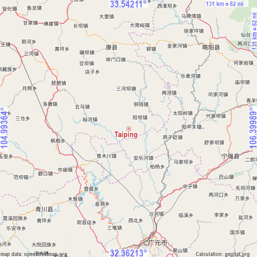
Taiping GPS coordinates[2]
32° 57' 14.724" North, 105° 41' 48.336" East
| Map corner | latitude | longitude |
|---|---|---|
| Upper-left | 33.54211°, | 104.99364° |
| Center: | 32.95409°, | 105.69676° |
| Lower-right: | 32.36213°, | 106.39989° |
| Map W x H: | 131.2×131.2 km | = 81.5×81.5mi |
| max Lat: | 53.31946° ⇑34.2% North |
| Taiping: | 32.95409° |
| min Lat: | ⇓65.8% South 18.22056° |
| min Long | Taiping | max Long |
| 75.07348° | 105.69676° | 134.28917° |
| W 12.2%⇐ | ⇒87.8% E |
Elevation
Elevation of Taiping is 1053 m = 3455 ft, and this is 568.2 m = 1864 ft above average elevation for this country.
| Max E: |
5622 m = 18445 ft | 13.9% |
| Taiping | 1053 m 3455 ft | |
| Avg. | 484.8 m = 1591 ft | |
Min E: |
-3 m = -10 ft | 86.1% |
See also: China elevation on elevation.city.
Geographical zone
Taiping is located in North temperate zone (between Tropic of Cancer and the Arctic Circle). Distance of this Northern Tropic circle is 1058.2 km =657.5 mi to South.| Distance of | km | miles | from Taiping |
|---|---|---|---|
| North Pole | 6342.9 | 3941.3 | to North |
| Arctic Circle | 3737 | 2322.1 | to North |
| Tropic Cancer | 1058.2 | 657.5 | to South |
| Equator | 3664.2 | 2276.8 | to South |


Nearby cities:
15 places around Taiping: (largest is in red/bold)
• Baiyang
25.6 km =15.9 mi,  18°
18°
• Cangdu
30.1 km =18.7 mi,  59°
59°
• Jia’an
34.3 km =21.3 mi,  3°
3°
• Lianghe
27.9 km =17.3 mi,  48°
48°
• Majiaba
32.8 km =20.4 mi,  121°
121°
• Sanheba
20.9 km =13 mi,  356°
356°
• Taiyangling
30 km =18.6 mi,  72°
72°
• Tongqian
14.2 km =8.8 mi,  26°
26°
• Tuohe
16.6 km =10.3 mi, 66°
• Wuma
26.6 km =16.5 mi,  297°
297°
• Yangba
9 km =5.6 mi, 46°
• Yangpingguan
33.3 km =20.7 mi,  88°
88°
• Yangtian
25.7 km =16 mi,  353°
353°
• Yanzibian
22.1 km =13.7 mi,  105°
105°
• Yuhe
20.3 km =12.6 mi,  284°
284°
Sources, notices
• [Note1] Compared only with cities in China existing in our database
• [Src1] Map data: © OpenStreetMap contributors (CC-BY-SA)
• [Src2] Other city data from geonames.org with taken over terms of usage.
• [Src3] Geographical zone / Annual Mean Temperature by Robert A. Rohde @ Wikipedia
