Xijiang geodata
Xijiang (Gansu) is a seat of a fourth-order administrative division; located in China in Asia/Shanghai (GMT+8) time zone. In our database, there are 1268 cities with bigger population. Compared to other cities in China, 73.1% of cities are located further ↓South; 90.3% of cities are located further →East and 95.5% of cities have lower elevation than Xijiang. Note1


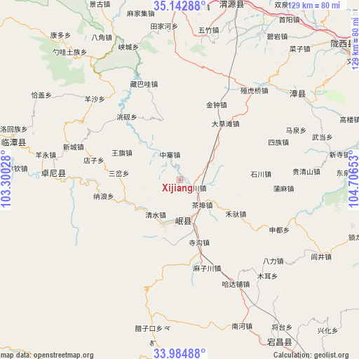
Xijiang GPS coordinates[2]
34° 33' 57.24" North, 104° 0' 12.24" East
| Map corner | latitude | longitude |
|---|---|---|
| Upper-left | 35.14288°, | 103.30028° |
| Center: | 34.5659°, | 104.0034° |
| Lower-right: | 33.98488°, | 104.70653° |
| Map W x H: | 128.8×128.8 km | = 80×80mi |
| max Lat: | 53.31946° ⇑26.9% North |
| Xijiang: | 34.5659° |
| min Lat: | ⇓73.1% South 18.22056° |
| min Long | Xijiang | max Long |
| 75.07348° | 104.0034° | 134.28917° |
| W 9.7%⇐ | ⇒90.3% E |
Elevation
Elevation of Xijiang is 2311 m = 7582 ft, and this is 1826.2 m = 5991 ft above average elevation for this country.
| Max E: |
5622 m = 18445 ft | 4.5% |
| Xijiang | 2311 m 7582 ft | |
| Avg. | 484.8 m = 1591 ft | |
Min E: |
-3 m = -10 ft | 95.5% |
See also: China elevation on elevation.city.
Geographical zone
Xijiang is located in North temperate zone (between Tropic of Cancer and the Arctic Circle). Distance of this Northern Tropic circle is 1237.4 km =768.9 mi to South.| Distance of | km | miles | from Xijiang |
|---|---|---|---|
| North Pole | 6163.7 | 3829.9 | to North |
| Arctic Circle | 3557.8 | 2210.7 | to North |
| Tropic Cancer | 1237.4 | 768.9 | to South |
| Equator | 3843.4 | 2388.2 | to South |


Nearby cities:
15 places around Xijiang: (largest is in red/bold)
• Baozi
16.3 km =10.1 mi,  315°
315°
• Chabu
12.1 km =7.5 mi,  136°
136°
• Chengjiao Chengguanzhen
14.7 km =9.1 mi,  170°
170°
• Chengjiao Zhen
14.9 km =9.3 mi, 167°
• Chenqi
19.9 km =12.4 mi,  312°
312°
• Meichuan Zhen
6.2 km =3.9 mi,  116°
116°
• Minshan
14.5 km =9 mi,  189°
189°
• Qingshui
15 km =9.3 mi,  217°
217°
• Qinxu
22.1 km =13.7 mi,  182°
182°
• Sancha
22.3 km =13.9 mi,  276°
276°
• Shili
16.5 km =10.3 mi,  196°
196°
• Weixin
16.7 km =10.4 mi, 312°
• Xiaozhai
8.2 km =5.1 mi,  6°
6°
• Xizhai
20.1 km =12.5 mi,  246°
246°
• Zhongzhai
9.8 km =6.1 mi,  338°
338°
Sources, notices
• [Note1] Compared only with cities in China existing in our database
• [Src1] Map data: © OpenStreetMap contributors (CC-BY-SA)
• [Src2] Other city data from geonames.org with taken over terms of usage.
• [Src3] Geographical zone / Annual Mean Temperature by Robert A. Rohde @ Wikipedia
