Qinxu geodata
Qinxu (Gansu) is a seat of a fourth-order administrative division; located in China in Asia/Shanghai (GMT+8) time zone. In our database, there are 1268 cities with bigger population. Compared to other cities in China, 71.9% of cities are located further ↓South; 90.3% of cities are located further →East and 95.8% of cities have lower elevation than Qinxu. Note1


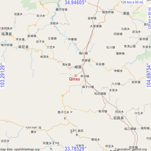
Qinxu GPS coordinates[2]
34° 22' 3.648" North, 103° 59' 39.876" East
| Map corner | latitude | longitude |
|---|---|---|
| Upper-left | 34.94605°, | 103.29129° |
| Center: | 34.36768°, | 103.99441° |
| Lower-right: | 33.78529°, | 104.69754° |
| Map W x H: | 129.1×129.1 km | = 80.2×80.2mi |
| max Lat: | 53.31946° ⇑28.1% North |
| Qinxu: | 34.36768° |
| min Lat: | ⇓71.9% South 18.22056° |
| min Long | Qinxu | max Long |
| 75.07348° | 103.99441° | 134.28917° |
| W 9.7%⇐ | ⇒90.3% E |
Elevation
Elevation of Qinxu is 2459 m = 8068 ft, and this is 1974.2 m = 6477 ft above average elevation for this country.
| Max E: |
5622 m = 18445 ft | 4.2% |
| Qinxu | 2459 m 8068 ft | |
| Avg. | 484.8 m = 1591 ft | |
Min E: |
-3 m = -10 ft | 95.8% |
See also: China elevation on elevation.city.
Geographical zone
Qinxu is located in North temperate zone (between Tropic of Cancer and the Arctic Circle). Distance of this Northern Tropic circle is 1215.4 km =755.2 mi to South.| Distance of | km | miles | from Qinxu |
|---|---|---|---|
| North Pole | 6185.7 | 3843.6 | to North |
| Arctic Circle | 3579.8 | 2224.4 | to North |
| Tropic Cancer | 1215.4 | 755.2 | to South |
| Equator | 3821.3 | 2374.4 | to South |


Nearby cities:
15 places around Qinxu: (largest is in red/bold)
• Chabu
16.2 km =10.1 mi,  34°
34°
• Chengjiao Chengguanzhen
8.3 km =5.2 mi,  23°
23°
• Chengjiao Zhen
8.6 km =5.3 mi, 29°
• Hadapu Zhen
25.9 km =16.1 mi,  125°
125°
• Meichuan Zhen
20.3 km =12.6 mi, 18°
• Minshan
7.9 km =4.9 mi,  347°
347°
• Nalang
31.6 km =19.6 mi,  301°
301°
• Qingshui
13.2 km =8.2 mi,  320°
320°
• Sancha
32.5 km =20.2 mi, 318°
• Shili
7.2 km =4.5 mi,  328°
328°
• Sigou
7.8 km =4.8 mi,  91°
91°
• Xiaozhai
30.2 km =18.8 mi,  3°
3°
• Xijiang
22.1 km =13.7 mi, 2°
• Xizhai
22.5 km =14 mi,  308°
308°
• Zhongzhai
31.3 km =19.4 mi,  355°
355°
Sources, notices
• [Note1] Compared only with cities in China existing in our database
• [Src1] Map data: © OpenStreetMap contributors (CC-BY-SA)
• [Src2] Other city data from geonames.org with taken over terms of usage.
• [Src3] Geographical zone / Annual Mean Temperature by Robert A. Rohde @ Wikipedia
