Magaozhuang geodata
Magaozhuang (Ningxia Hui Autonomous Region) is a seat of a fourth-order administrative division; located in China in Asia/Shanghai (GMT+8) time zone. In our database, there are 1268 cities with bigger population. Compared to other cities in China, 78.9% of cities are located further ↓South; 85.3% of cities are located further →East and 91.9% of cities have lower elevation than Magaozhuang. Note1


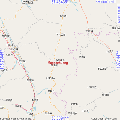
Magaozhuang GPS coordinates[2]
36° 52' 26.22" North, 106° 26' 29.652" East
| Map corner | latitude | longitude |
|---|---|---|
| Upper-left | 37.43435°, | 105.73845° |
| Center: | 36.87395°, | 106.44157° |
| Lower-right: | 36.30941°, | 107.1447° |
| Map W x H: | 125.1×125.1 km | = 77.7×77.7mi |
| max Lat: | 53.31946° ⇑21.1% North |
| Magaozhuang: | 36.87395° |
| min Lat: | ⇓78.9% South 18.22056° |
| min Long | Magaozhuang | max Long |
| 75.07348° | 106.44157° | 134.28917° |
| W 14.7%⇐ | ⇒85.3% E |
Elevation
Elevation of Magaozhuang is 1554 m = 5098 ft, and this is 1069.2 m = 3508 ft above average elevation for this country.
| Max E: |
5622 m = 18445 ft | 8.1% |
| Magaozhuang | 1554 m 5098 ft | |
| Avg. | 484.8 m = 1591 ft | |
Min E: |
-3 m = -10 ft | 91.9% |
See also: China elevation on elevation.city.
Geographical zone
Magaozhuang is located in North temperate zone (between Tropic of Cancer and the Arctic Circle). Distance of this Northern Tropic circle is 1494.1 km =928.4 mi to South.| Distance of | km | miles | from Magaozhuang |
|---|---|---|---|
| North Pole | 5907.1 | 3670.5 | to North |
| Arctic Circle | 3301.2 | 2051.3 | to North |
| Tropic Cancer | 1494.1 | 928.4 | to South |
| Equator | 4100 | 2547.6 | to South |


Nearby cities:
15 places around Magaozhuang: (largest is in red/bold)
• Gancheng
32.7 km =20.3 mi,  196°
196°
• Gaotai
47.6 km =29.6 mi,  186°
186°
• Liwang
38 km =23.6 mi,  232°
232°
• Luochuan
48.8 km =30.3 mi, 233°
• Luoshanchuan
45.8 km =28.5 mi,  100°
100°
• Maojing
47.8 km =29.7 mi,  162°
162°
• Maqu
53.2 km =33.1 mi,  177°
177°
• Nanqiu
25.2 km =15.7 mi,  83°
83°
• Qiying
48.8 km =30.3 mi,  212°
212°
• Shancheng
52.8 km =32.8 mi, 79°
• Xiaonangou
43.5 km =27 mi,  129°
129°
• Yanglu
37.6 km =23.4 mi, 225°
• Yuhai
49.1 km =30.5 mi,  284°
284°
• Yuwang
8.3 km =5.2 mi,  223°
223°
• Zhangjiayuan
19.5 km =12.1 mi, 209°
Sources, notices
• [Note1] Compared only with cities in China existing in our database
• [Src1] Map data: © OpenStreetMap contributors (CC-BY-SA)
• [Src2] Other city data from geonames.org with taken over terms of usage.
• [Src3] Geographical zone / Annual Mean Temperature by Robert A. Rohde @ Wikipedia
