Yuhai geodata
Yuhai (Ningxia Hui Autonomous Region) is a seat of a third-order administrative division; located in China in Asia/Shanghai (GMT+8) time zone. In our database, there are 1268 cities with bigger population. Compared to other cities in China, 79.1% of cities are located further ↓South; 87.2% of cities are located further →East and 89.8% of cities have lower elevation than Yuhai. Note1


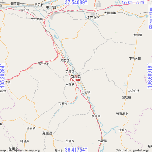
Yuhai GPS coordinates[2]
36° 58' 52.644" North, 105° 54' 21.816" East
| Map corner | latitude | longitude |
|---|---|---|
| Upper-left | 37.54089°, | 105.20294° |
| Center: | 36.98129°, | 105.90606° |
| Lower-right: | 36.41754°, | 106.60919° |
| Map W x H: | 124.9×124.9 km | = 77.6×77.6mi |
| max Lat: | 53.31946° ⇑20.9% North |
| Yuhai: | 36.98129° |
| min Lat: | ⇓79.1% South 18.22056° |
| min Long | Yuhai | max Long |
| 75.07348° | 105.90606° | 134.28917° |
| W 12.8%⇐ | ⇒87.2% E |
Elevation
Elevation of Yuhai is 1346 m = 4416 ft, and this is 861.2 m = 2825 ft above average elevation for this country.
| Max E: |
5622 m = 18445 ft | 10.2% |
| Yuhai | 1346 m 4416 ft | |
| Avg. | 484.8 m = 1591 ft | |
Min E: |
-3 m = -10 ft | 89.8% |
See also: China elevation on elevation.city.
Geographical zone
Yuhai is located in North temperate zone (between Tropic of Cancer and the Arctic Circle). Distance of this Northern Tropic circle is 1506 km =935.8 mi to South.| Distance of | km | miles | from Yuhai |
|---|---|---|---|
| North Pole | 5895.1 | 3663 | to North |
| Arctic Circle | 3289.2 | 2043.8 | to North |
| Tropic Cancer | 1506 | 935.8 | to South |
| Equator | 4111.9 | 2555 | to South |


Nearby cities:
15 places around Yuhai: (largest is in red/bold)
• Gancheng
58 km =36 mi,  138°
138°
• Gaotai
72.6 km =45.1 mi, 144°
• Heicheng
69.8 km =43.4 mi,  166°
166°
• Hongsipu
48.4 km =30.1 mi,  16°
16°
• Liwang
39 km =24.2 mi,  153°
153°
• Luochuan
41.9 km =26 mi, 168°
• Magaozhuang
49.1 km =30.5 mi,  104°
104°
• Nanqiu
73.2 km =45.5 mi, 97°
• Ning’an
60.9 km =37.8 mi,  340°
340°
• Qiying
57.4 km =35.7 mi,  157°
157°
• Sanhe
52.1 km =32.4 mi,  207°
207°
• Tanshan
76 km =47.2 mi, 152°
• Yanglu
43.7 km =27.2 mi, 151°
• Yuwang
45.6 km =28.3 mi,  113°
113°
• Zhangjiayuan
47.7 km =29.6 mi,  127°
127°
Sources, notices
• [Note1] Compared only with cities in China existing in our database
• [Src1] Map data: © OpenStreetMap contributors (CC-BY-SA)
• [Src2] Other city data from geonames.org with taken over terms of usage.
• [Src3] Geographical zone / Annual Mean Temperature by Robert A. Rohde @ Wikipedia
