Nanqiu geodata
Nanqiu (Gansu) is a seat of a fourth-order administrative division; located in China in Asia/Shanghai (GMT+8) time zone. In our database, there are 1268 cities with bigger population. Compared to other cities in China, 79% of cities are located further ↓South; 84.5% of cities are located further →East and 93.2% of cities have lower elevation than Nanqiu. Note1


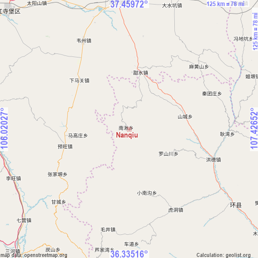
Nanqiu GPS coordinates[2]
36° 53' 58.236" North, 106° 43' 24.204" East
| Map corner | latitude | longitude |
|---|---|---|
| Upper-left | 37.45972°, | 106.02027° |
| Center: | 36.89951°, | 106.72339° |
| Lower-right: | 36.33516°, | 107.42652° |
| Map W x H: | 125×125 km | = 77.7×77.7mi |
| max Lat: | 53.31946° ⇑21% North |
| Nanqiu: | 36.89951° |
| min Lat: | ⇓79% South 18.22056° |
| min Long | Nanqiu | max Long |
| 75.07348° | 106.72339° | 134.28917° |
| W 15.5%⇐ | ⇒84.5% E |
Elevation
Elevation of Nanqiu is 1735 m = 5692 ft, and this is 1250.2 m = 4102 ft above average elevation for this country.
| Max E: |
5622 m = 18445 ft | 6.8% |
| Nanqiu | 1735 m 5692 ft | |
| Avg. | 484.8 m = 1591 ft | |
Min E: |
-3 m = -10 ft | 93.2% |
See also: China elevation on elevation.city.
Geographical zone
Nanqiu is located in North temperate zone (between Tropic of Cancer and the Arctic Circle). Distance of this Northern Tropic circle is 1496.9 km =930.1 mi to South.| Distance of | km | miles | from Nanqiu |
|---|---|---|---|
| North Pole | 5904.2 | 3668.7 | to North |
| Arctic Circle | 3298.3 | 2049.5 | to North |
| Tropic Cancer | 1496.9 | 930.1 | to South |
| Equator | 4102.8 | 2549.4 | to South |


Nearby cities:
15 places around Nanqiu: (largest is in red/bold)
• Chedao
55.5 km =34.5 mi,  178°
178°
• Gancheng
48.4 km =30.1 mi,  224°
224°
• Gaotai
58.8 km =36.5 mi,  211°
211°
• Gengwan
47.6 km =29.6 mi,  92°
92°
• Hongde
44.6 km =27.7 mi,  113°
113°
• Hudong
44.8 km =27.8 mi,  150°
150°
• Luoshanchuan
23 km =14.3 mi,  119°
119°
• Magaozhuang
25.2 km =15.7 mi,  263°
263°
• Maojing
49.5 km =30.8 mi,  192°
192°
• Shancheng
27.7 km =17.2 mi,  76°
76°
• Xiaonangou
31.7 km =19.7 mi,  164°
164°
• Xichuan
58.9 km =36.6 mi,  139°
139°
• Yuanmao
50.4 km =31.3 mi, 178°
• Yuwang
32 km =19.9 mi,  253°
253°
• Zhangjiayuan
40 km =24.9 mi,  240°
240°
Sources, notices
• [Note1] Compared only with cities in China existing in our database
• [Src1] Map data: © OpenStreetMap contributors (CC-BY-SA)
• [Src2] Other city data from geonames.org with taken over terms of usage.
• [Src3] Geographical zone / Annual Mean Temperature by Robert A. Rohde @ Wikipedia
