Zhangjiayuan geodata
Zhangjiayuan (Ningxia Hui Autonomous Region) is a seat of a fourth-order administrative division; located in China in Asia/Shanghai (GMT+8) time zone. In our database, there are 1268 cities with bigger population. Compared to other cities in China, 78.6% of cities are located further ↓South; 85.7% of cities are located further →East and 93% of cities have lower elevation than Zhangjiayuan. Note1


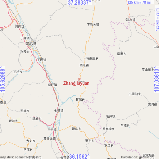
Zhangjiayuan GPS coordinates[2]
36° 43' 18.66" North, 106° 19' 58.8" East
| Map corner | latitude | longitude |
|---|---|---|
| Upper-left | 37.28337°, | 105.62988° |
| Center: | 36.72185°, | 106.333° |
| Lower-right: | 36.1562°, | 107.03613° |
| Map W x H: | 125.3×125.3 km | = 77.9×77.9mi |
| max Lat: | 53.31946° ⇑21.4% North |
| Zhangjiayuan: | 36.72185° |
| min Lat: | ⇓78.6% South 18.22056° |
| min Long | Zhangjiayuan | max Long |
| 75.07348° | 106.333° | 134.28917° |
| W 14.3%⇐ | ⇒85.7% E |
Elevation
Elevation of Zhangjiayuan is 1717 m = 5633 ft, and this is 1232.2 m = 4043 ft above average elevation for this country.
| Max E: |
5622 m = 18445 ft | 7% |
| Zhangjiayuan | 1717 m 5633 ft | |
| Avg. | 484.8 m = 1591 ft | |
Min E: |
-3 m = -10 ft | 93% |
See also: China elevation on elevation.city.
Geographical zone
Zhangjiayuan is located in North temperate zone (between Tropic of Cancer and the Arctic Circle). Distance of this Northern Tropic circle is 1477.2 km =917.9 mi to South.| Distance of | km | miles | from Zhangjiayuan |
|---|---|---|---|
| North Pole | 5924 | 3681 | to North |
| Arctic Circle | 3318.1 | 2061.8 | to North |
| Tropic Cancer | 1477.2 | 917.9 | to South |
| Equator | 4083.1 | 2537.1 | to South |


Nearby cities:
15 places around Zhangjiayuan: (largest is in red/bold)
• Gancheng
14.5 km =9 mi,  177°
177°
• Gaotai
30.6 km =19 mi,  172°
172°
• Gongbailiang
38.6 km =24 mi, 183°
• Liwang
21.5 km =13.4 mi,  253°
253°
• Luochuan
32 km =19.9 mi, 247°
• Magaozhuang
19.5 km =12.1 mi,  29°
29°
• Maojing
37.6 km =23.4 mi,  139°
139°
• Maqu
38.2 km =23.7 mi,  161°
161°
• Nanqiu
40 km =24.9 mi,  60°
60°
• Qiying
29.4 km =18.3 mi,  214°
214°
• Tanshan
38.4 km =23.9 mi, 183°
• Xiaonangou
44.6 km =27.7 mi,  104°
104°
• Xinshan
41 km =25.5 mi, 174°
• Yanglu
19.5 km =12.1 mi,  240°
240°
• Yuwang
11.5 km =7.1 mi,  20°
20°
Sources, notices
• [Note1] Compared only with cities in China existing in our database
• [Src1] Map data: © OpenStreetMap contributors (CC-BY-SA)
• [Src2] Other city data from geonames.org with taken over terms of usage.
• [Src3] Geographical zone / Annual Mean Temperature by Robert A. Rohde @ Wikipedia
