Juren geodata
Juren (Heilongjiang) is a seat of a fourth-order administrative division; located in China in Asia/Shanghai (GMT+8) time zone. In our database, there are 1268 cities with bigger population. Compared to other cities in China, 94.7% of cities are located further ↓South; 97.2% of cities are located further ←West and 50.2% of cities have higher elevation than Juren. Note1


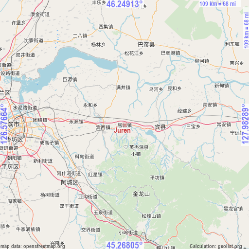
Juren GPS coordinates[2]
45° 45' 38.7" North, 127° 16' 47.136" East
| Map corner | latitude | longitude |
|---|---|---|
| Upper-left | 46.24913°, | 126.57664° |
| Center: | 45.76075°, | 127.27976° |
| Lower-right: | 45.26805°, | 127.98289° |
| Map W x H: | 109.1×109.1 km | = 67.8×67.8mi |
| max Lat: | 53.31946° ⇑5.3% North |
| Juren: | 45.76075° |
| min Lat: | ⇓94.7% South 18.22056° |
| min Long | Juren | max Long |
| 75.07348° | 127.27976° | 134.28917° |
| W 97.2%⇐ | ⇒2.8% E |
Elevation
Elevation of Juren is 163 m = 535 ft, and this is 321.8 m = 1056 ft below average elevation for this country.
| Max E: |
5622 m = 18445 ft | 50.2% |
| Avg. | 484.8 m = 1591 ft | |
| Juren | 163 m = 535 ft | |
Min E: |
-3 m = -10 ft | 49.8% |
See also: China elevation on elevation.city.
Geographical zone
Juren is located in North temperate zone (between Tropic of Cancer and the Arctic Circle). Distance of this North polar circle is 2313.1 km =1437.3 mi to North.| Distance of | km | miles | from Juren |
|---|---|---|---|
| North Pole | 4918.9 | 3056.5 | to North |
| Arctic Circle | 2313.1 | 1437.3 | to North |
| Tropic Cancer | 2482.2 | 1542.4 | to South |
| Equator | 5088.1 | 3161.6 | to South |


Nearby cities:
15 places around Juren: (largest is in red/bold)
• Binxi
9.7 km =6 mi,  262°
262°
• Binzhou
15.5 km =9.6 mi,  93°
93°
• Feiketu
10.6 km =6.6 mi, 261°
• Hongxing
25.3 km =15.7 mi,  211°
211°
• Jingjian
27.3 km =17 mi,  76°
76°
• Liaodian
22.6 km =14 mi,  230°
230°
• Manjing
16.5 km =10.3 mi,  357°
357°
• Minhe
27.2 km =16.9 mi,  53°
53°
• Niaohe
20.9 km =13 mi,  41°
41°
• Pingfang
27.1 km =16.8 mi,  148°
148°
• Tangfang
23.9 km =14.9 mi,  313°
313°
• Xiangyang
27.7 km =17.2 mi,  268°
268°
• Yonghe
15.4 km =9.6 mi,  299°
299°
• Yonghe
17.3 km =10.7 mi, 300°
• Yongyuan
21.1 km =13.1 mi, 273°
Sources, notices
• [Note1] Compared only with cities in China existing in our database
• [Src1] Map data: © OpenStreetMap contributors (CC-BY-SA)
• [Src2] Other city data from geonames.org with taken over terms of usage.
• [Src3] Geographical zone / Annual Mean Temperature by Robert A. Rohde @ Wikipedia
