Pingfang geodata
Pingfang (Heilongjiang) is a seat of a fourth-order administrative division; located in China in Asia/Shanghai (GMT+8) time zone. In our database, there are 1268 cities with bigger population. Compared to other cities in China, 94.4% of cities are located further ↓South; 97.5% of cities are located further ←West and 66% of cities have lower elevation than Pingfang. Note1


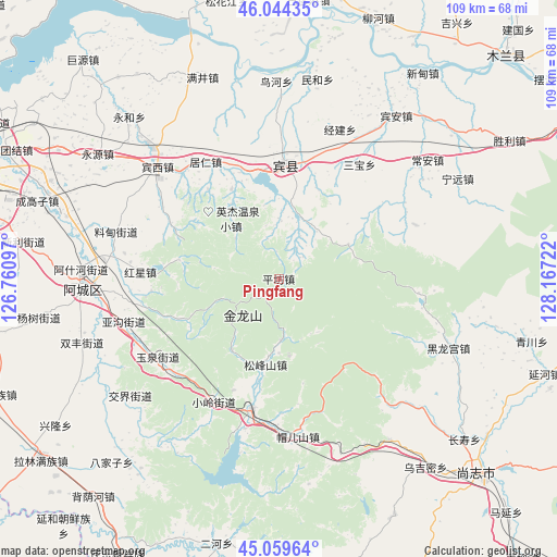
Pingfang GPS coordinates[2]
45° 33' 14.94" North, 127° 27' 50.724" East
| Map corner | latitude | longitude |
|---|---|---|
| Upper-left | 46.04435°, | 126.76097° |
| Center: | 45.55415°, | 127.46409° |
| Lower-right: | 45.05964°, | 128.16722° |
| Map W x H: | 109.5×109.5 km | = 68×68mi |
| max Lat: | 53.31946° ⇑5.6% North |
| Pingfang: | 45.55415° |
| min Lat: | ⇓94.4% South 18.22056° |
| min Long | Pingfang | max Long |
| 75.07348° | 127.46409° | 134.28917° |
| W 97.5%⇐ | ⇒2.5% E |
Elevation
Elevation of Pingfang is 343 m = 1125 ft, and this is 141.8 m = 465 ft below average elevation for this country.
| Max E: |
5622 m = 18445 ft | 34% |
| Avg. | 484.8 m = 1591 ft | |
| Pingfang | 343 m = 1125 ft | |
Min E: |
-3 m = -10 ft | 66% |
See also: China elevation on elevation.city.
Geographical zone
Pingfang is located in North temperate zone (between Tropic of Cancer and the Arctic Circle). Distance of this North polar circle is 2336 km =1451.5 mi to North.| Distance of | km | miles | from Pingfang |
|---|---|---|---|
| North Pole | 4941.9 | 3070.8 | to North |
| Arctic Circle | 2336 | 1451.5 | to North |
| Tropic Cancer | 2459.2 | 1528.1 | to South |
| Equator | 5065.1 | 3147.3 | to South |


Nearby cities:
15 places around Pingfang: (largest is in red/bold)
• Binxi
32.3 km =20.1 mi,  312°
312°
• Binzhou
22.1 km =13.7 mi,  3°
3°
• Daling
27.9 km =17.3 mi,  259°
259°
• Feiketu
32.8 km =20.4 mi, 310°
• Guang’en
29.3 km =18.2 mi,  69°
69°
• Hongxing
27.5 km =17.1 mi,  272°
272°
• Jingjian
31.7 km =19.7 mi,  22°
22°
• Juren
27.1 km =16.8 mi,  328°
328°
• Mao’ershan
31.1 km =19.3 mi,  174°
174°
• Pingshan
26.2 km =16.3 mi,  191°
191°
• Sanbao
27.5 km =17.1 mi,  35°
35°
• Songfengshan
17.1 km =10.6 mi, 188°
• Xiaoling
27.2 km =16.9 mi,  207°
207°
• Yagou
31.1 km =19.3 mi,  254°
254°
• Yuquan
28.7 km =17.8 mi,  236°
236°
Sources, notices
• [Note1] Compared only with cities in China existing in our database
• [Src1] Map data: © OpenStreetMap contributors (CC-BY-SA)
• [Src2] Other city data from geonames.org with taken over terms of usage.
• [Src3] Geographical zone / Annual Mean Temperature by Robert A. Rohde @ Wikipedia
