Yinghua geodata
Yinghua (Guangdong) is a seat of a fourth-order administrative division; located in China in Asia/Shanghai (GMT+8) time zone. In our database, there are 1268 cities with bigger population. Compared to other cities in China, 89.5% of cities are located further ↑North; 53.3% of cities are located further →East and 64.5% of cities have higher elevation than Yinghua. Note1


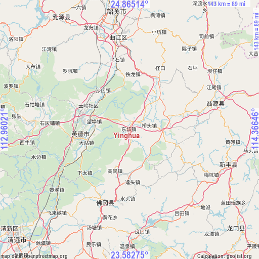
Yinghua GPS coordinates[2]
24° 13' 32.016" North, 113° 39' 47.988" East
| Map corner | latitude | longitude |
|---|---|---|
| Upper-left | 24.86514°, | 112.96021° |
| Center: | 24.22556°, | 113.66333° |
| Lower-right: | 23.58275°, | 114.36646° |
| Map W x H: | 142.6×142.6 km | = 88.6×88.6mi |
| max Lat: | 53.31946° ⇑89.5% North |
| Yinghua: | 24.22556° |
| min Lat: | ⇓10.5% South 18.22056° |
| min Long | Yinghua | max Long |
| 75.07348° | 113.66333° | 134.28917° |
| W 46.7%⇐ | ⇒53.3% E |
Elevation
Elevation of Yinghua is 75 m = 246 ft, and this is 409.8 m = 1344 ft below average elevation for this country.
| Max E: |
5622 m = 18445 ft | 64.5% |
| Avg. | 484.8 m = 1591 ft | |
| Yinghua | 75 m = 246 ft | |
Min E: |
-3 m = -10 ft | 35.5% |
See also: China elevation on elevation.city.
Geographical zone
Yinghua is located in North temperate zone (between Tropic of Cancer and the Arctic Circle). Distance of this Northern Tropic circle is 87.7 km =54.5 mi to South.| Distance of | km | miles | from Yinghua |
|---|---|---|---|
| North Pole | 7313.4 | 4544.3 | to North |
| Arctic Circle | 4707.5 | 2925.1 | to North |
| Tropic Cancer | 87.7 | 54.5 | to South |
| Equator | 2693.6 | 1673.7 | to South |


Nearby cities:
15 places around Yinghua: (largest is in red/bold)
• Baisha
17.8 km =11.1 mi,  147°
147°
• Donghua
0.7 km =0.4 mi,  18°
18°
• Gaogang
24.3 km =15.1 mi,  200°
200°
• Guandu
23.2 km =14.4 mi,  73°
73°
• Hengshishui
20.1 km =12.5 mi,  43°
43°
• Huanggang
19.6 km =12.2 mi,  238°
238°
• Miaodun
25.2 km =15.7 mi,  84°
84°
• Qiaotou
11.4 km =7.1 mi, 74°
• Qingtang
18.4 km =11.4 mi,  93°
93°
• Wangbu
18.2 km =11.3 mi,  284°
284°
• Wengcheng
23.5 km =14.6 mi, 44°
• Xianggui
19.1 km =11.9 mi, 148°
• Yingcheng
26.3 km =16.3 mi,  255°
255°
• Yunling
26.5 km =16.5 mi,  300°
300°
• Yuwan
6.8 km =4.2 mi,  178°
178°
Sources, notices
• [Note1] Compared only with cities in China existing in our database
• [Src1] Map data: © OpenStreetMap contributors (CC-BY-SA)
• [Src2] Other city data from geonames.org with taken over terms of usage.
• [Src3] Geographical zone / Annual Mean Temperature by Robert A. Rohde @ Wikipedia
