Qiaotou geodata
Qiaotou (Guangdong) is a seat of a fourth-order administrative division; located in China in Asia/Shanghai (GMT+8) time zone. In our database, there are 1268 cities with bigger population. Compared to other cities in China, 89.4% of cities are located further ↑North; 52.7% of cities are located further →East and 60.6% of cities have higher elevation than Qiaotou. Note1


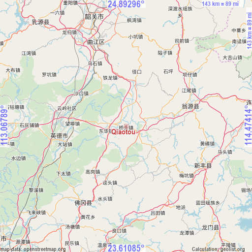
Qiaotou GPS coordinates[2]
24° 15' 12.672" North, 113° 46' 15.636" East
| Map corner | latitude | longitude |
|---|---|---|
| Upper-left | 24.89296°, | 113.06789° |
| Center: | 24.25352°, | 113.77101° |
| Lower-right: | 23.61085°, | 114.47414° |
| Map W x H: | 142.6×142.6 km | = 88.6×88.6mi |
| max Lat: | 53.31946° ⇑89.4% North |
| Qiaotou: | 24.25352° |
| min Lat: | ⇓10.6% South 18.22056° |
| min Long | Qiaotou | max Long |
| 75.07348° | 113.77101° | 134.28917° |
| W 47.3%⇐ | ⇒52.7% E |
Elevation
Elevation of Qiaotou is 95 m = 312 ft, and this is 389.8 m = 1279 ft below average elevation for this country.
| Max E: |
5622 m = 18445 ft | 60.6% |
| Avg. | 484.8 m = 1591 ft | |
| Qiaotou | 95 m = 312 ft | |
Min E: |
-3 m = -10 ft | 39.4% |
See also: China elevation on elevation.city.
Geographical zone
Qiaotou is located in North temperate zone (between Tropic of Cancer and the Arctic Circle). Distance of this Northern Tropic circle is 90.8 km =56.4 mi to South.| Distance of | km | miles | from Qiaotou |
|---|---|---|---|
| North Pole | 7310.3 | 4542.4 | to North |
| Arctic Circle | 4704.4 | 2923.2 | to North |
| Tropic Cancer | 90.8 | 56.4 | to South |
| Equator | 2696.7 | 1675.7 | to South |


Nearby cities:
15 places around Qiaotou: (largest is in red/bold)
• Baisha
18.2 km =11.3 mi,  184°
184°
• Donghua
11 km =6.8 mi,  256°
256°
• Guandu
11.9 km =7.4 mi,  73°
73°
• Hengshishui
11.8 km =7.3 mi,  15°
15°
• Huilong
19.5 km =12.1 mi,  125°
125°
• Liuli
20.7 km =12.9 mi, 71°
• Miaodun
14.2 km =8.8 mi,  93°
93°
• Qingtang
8.6 km =5.3 mi,  119°
119°
• Qixia
27.7 km =17.2 mi,  104°
104°
• Wengcheng
14.7 km =9.1 mi, 22°
• Xianggui
19.4 km =12.1 mi, 183°
• Xinjiang
24.7 km =15.3 mi,  14°
14°
• Yinghua
11.4 km =7.1 mi,  254°
254°
• Yuwan
14.6 km =9.1 mi,  227°
227°
• Zhoupi
25.3 km =15.7 mi, 90°
Sources, notices
• [Note1] Compared only with cities in China existing in our database
• [Src1] Map data: © OpenStreetMap contributors (CC-BY-SA)
• [Src2] Other city data from geonames.org with taken over terms of usage.
• [Src3] Geographical zone / Annual Mean Temperature by Robert A. Rohde @ Wikipedia
