Baisha geodata
Baisha (Guangdong) is a seat of a fourth-order administrative division; located in China in Asia/Shanghai (GMT+8) time zone. In our database, there are 1268 cities with bigger population. Compared to other cities in China, 90.1% of cities are located further ↑North; 52.8% of cities are located further →East and 61.3% of cities have higher elevation than Baisha. Note1


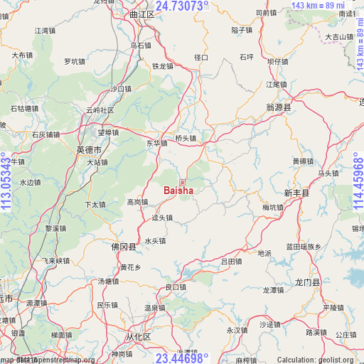
Baisha GPS coordinates[2]
24° 5' 25.656" North, 113° 45' 23.58" East
| Map corner | latitude | longitude |
|---|---|---|
| Upper-left | 24.73073°, | 113.05343° |
| Center: | 24.09046°, | 113.75655° |
| Lower-right: | 23.44698°, | 114.45968° |
| Map W x H: | 142.7×142.7 km | = 88.7×88.7mi |
| max Lat: | 53.31946° ⇑90.1% North |
| Baisha: | 24.09046° |
| min Lat: | ⇓9.9% South 18.22056° |
| min Long | Baisha | max Long |
| 75.07348° | 113.75655° | 134.28917° |
| W 47.2%⇐ | ⇒52.8% E |
Elevation
Elevation of Baisha is 91 m = 299 ft, and this is 393.8 m = 1292 ft below average elevation for this country.
| Max E: |
5622 m = 18445 ft | 61.3% |
| Avg. | 484.8 m = 1591 ft | |
| Baisha | 91 m = 299 ft | |
Min E: |
-3 m = -10 ft | 38.7% |
See also: China elevation on elevation.city.
Geographical zone
Baisha is located in North temperate zone (between Tropic of Cancer and the Arctic Circle). Distance of this Northern Tropic circle is 72.7 km =45.2 mi to South.| Distance of | km | miles | from Baisha |
|---|---|---|---|
| North Pole | 7328.5 | 4553.7 | to North |
| Arctic Circle | 4722.6 | 2934.5 | to North |
| Tropic Cancer | 72.7 | 45.2 | to South |
| Equator | 2678.6 | 1664.4 | to South |


Nearby cities:
15 places around Baisha: (largest is in red/bold)
• Donghua
18.2 km =11.3 mi,  329°
329°
• Gaogang
19.5 km =12.1 mi,  246°
246°
• Guandu
25 km =15.5 mi,  30°
30°
• Huanggang
26.6 km =16.5 mi,  280°
280°
• Huilong
18.6 km =11.6 mi,  68°
68°
• Jingtou
15.6 km =9.7 mi,  210°
210°
• Miaodun
23.3 km =14.5 mi,  42°
42°
• Qiaotou
18.2 km =11.3 mi,  4°
4°
• Qingtang
16.5 km =10.3 mi, 32°
• Shatian
21.4 km =13.3 mi,  123°
123°
• Shuitou
25.1 km =15.6 mi, 205°
• Xianggui
1.4 km =0.9 mi,  161°
161°
• Yaotian
13.9 km =8.6 mi,  149°
149°
• Yinghua
17.8 km =11.1 mi, 327°
• Yuwan
12.4 km =7.7 mi,  311°
311°
Sources, notices
• [Note1] Compared only with cities in China existing in our database
• [Src1] Map data: © OpenStreetMap contributors (CC-BY-SA)
• [Src2] Other city data from geonames.org with taken over terms of usage.
• [Src3] Geographical zone / Annual Mean Temperature by Robert A. Rohde @ Wikipedia
