Guandu geodata
Guandu (Guangdong) is a seat of a fourth-order administrative division; located in China in Asia/Shanghai (GMT+8) time zone. In our database, there are 1268 cities with bigger population. Compared to other cities in China, 89.3% of cities are located further ↑North; 52.1% of cities are located further →East and 59.5% of cities have higher elevation than Guandu. Note1


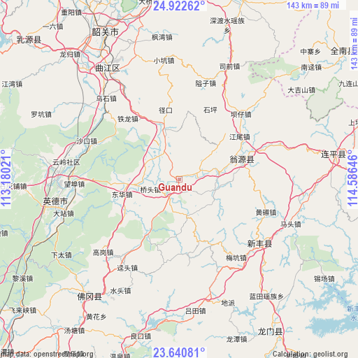
Guandu GPS coordinates[2]
24° 16' 59.988" North, 113° 52' 59.988" East
| Map corner | latitude | longitude |
|---|---|---|
| Upper-left | 24.92262°, | 113.18021° |
| Center: | 24.28333°, | 113.88333° |
| Lower-right: | 23.64081°, | 114.58646° |
| Map W x H: | 142.5×142.5 km | = 88.5×88.5mi |
| max Lat: | 53.31946° ⇑89.3% North |
| Guandu: | 24.28333° |
| min Lat: | ⇓10.7% South 18.22056° |
| min Long | Guandu | max Long |
| 75.07348° | 113.88333° | 134.28917° |
| W 47.9%⇐ | ⇒52.1% E |
Elevation
Elevation of Guandu is 101 m = 331 ft, and this is 383.8 m = 1259 ft below average elevation for this country.
| Max E: |
5622 m = 18445 ft | 59.5% |
| Avg. | 484.8 m = 1591 ft | |
| Guandu | 101 m = 331 ft | |
Min E: |
-3 m = -10 ft | 40.5% |
See also: China elevation on elevation.city.
Geographical zone
Guandu is located in North temperate zone (between Tropic of Cancer and the Arctic Circle). Distance of this Northern Tropic circle is 94.1 km =58.5 mi to South.| Distance of | km | miles | from Guandu |
|---|---|---|---|
| North Pole | 7307 | 4540.4 | to North |
| Arctic Circle | 4701.1 | 2921.1 | to North |
| Tropic Cancer | 94.1 | 58.5 | to South |
| Equator | 2700.1 | 1677.8 | to South |


Nearby cities:
15 places around Guandu: (largest is in red/bold)
• Baisha
25 km =15.5 mi,  210°
210°
• Donghua
22.8 km =14.2 mi,  255°
255°
• Hengshishui
11.6 km =7.2 mi,  314°
314°
• Hongling
22.2 km =13.8 mi,  19°
19°
• Huilong
15.3 km =9.5 mi,  163°
163°
• Liuli
8.9 km =5.5 mi,  69°
69°
• Miaodun
5.1 km =3.2 mi,  146°
146°
• Qiaotou
11.9 km =7.4 mi,  253°
253°
• Qingtang
8.6 km =5.3 mi, 207°
• Qixia
18.6 km =11.6 mi,  124°
124°
• Wengcheng
11.8 km =7.3 mi,  330°
330°
• Xinjiang
21.3 km =13.2 mi,  345°
345°
• Yinghua
23.2 km =14.4 mi, 253°
• Yuwan
25.8 km =16 mi,  239°
239°
• Zhoupi
14.3 km =8.9 mi,  104°
104°
Sources, notices
• [Note1] Compared only with cities in China existing in our database
• [Src1] Map data: © OpenStreetMap contributors (CC-BY-SA)
• [Src2] Other city data from geonames.org with taken over terms of usage.
• [Src3] Geographical zone / Annual Mean Temperature by Robert A. Rohde @ Wikipedia
