Xiangyanghu geodata
Xiangyanghu (Hubei) is a seat of a fourth-order administrative division; located in China in Asia/Shanghai (GMT+8) time zone. In our database, there are 1268 cities with bigger population. Compared to other cities in China, 55% of cities are located further ↑North; 50.3% of cities are located further →East and 73.3% of cities have higher elevation than Xiangyanghu. Note1


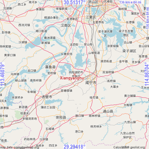
Xiangyanghu GPS coordinates[2]
29° 54' 19.944" North, 114° 9' 50.076" East
| Map corner | latitude | longitude |
|---|---|---|
| Upper-left | 30.51317°, | 113.46079° |
| Center: | 29.90554°, | 114.16391° |
| Lower-right: | 29.29418°, | 114.86704° |
| Map W x H: | 135.5×135.5 km | = 84.2×84.2mi |
| max Lat: | 53.31946° ⇑55% North |
| Xiangyanghu: | 29.90554° |
| min Lat: | ⇓45% South 18.22056° |
| min Long | Xiangyanghu | max Long |
| 75.07348° | 114.16391° | 134.28917° |
| W 49.7%⇐ | ⇒50.3% E |
Elevation
Elevation of Xiangyanghu is 41 m = 135 ft, and this is 443.8 m = 1456 ft below average elevation for this country.
| Max E: |
5622 m = 18445 ft | 73.3% |
| Avg. | 484.8 m = 1591 ft | |
| Xiangyanghu | 41 m = 135 ft | |
Min E: |
-3 m = -10 ft | 26.7% |
See also: China elevation on elevation.city.
Geographical zone
Xiangyanghu is located in North temperate zone (between Tropic of Cancer and the Arctic Circle). Distance of this Northern Tropic circle is 719.3 km =447 mi to South.| Distance of | km | miles | from Xiangyanghu |
|---|---|---|---|
| North Pole | 6681.9 | 4151.9 | to North |
| Arctic Circle | 4076 | 2532.7 | to North |
| Tropic Cancer | 719.3 | 447 | to South |
| Equator | 3325.2 | 2066.2 | to South |


Nearby cities:
15 places around Xiangyanghu: (largest is in red/bold)
• Fasi
27.9 km =17.3 mi,  358°
358°
• Fushan
14.9 km =9.3 mi,  107°
107°
• Guanbuqiao
14.9 km =9.3 mi,  92°
92°
• Guanqiao
21.5 km =13.4 mi,  274°
274°
• Guantangyi
16.3 km =10.1 mi,  207°
207°
• Guihua
27.2 km =16.9 mi,  140°
140°
• Henggouqiao
18.8 km =11.7 mi,  80°
80°
• Maqiao
21.4 km =13.3 mi,  120°
120°
• Shenshan
13.4 km =8.3 mi, 266°
• Shuangxiqiao
30.6 km =19 mi, 85°
• Tingsiqiao
9.9 km =6.2 mi,  178°
178°
• Xianning
16.7 km =10.4 mi, 114°
• Xinjie
20.5 km =12.7 mi,  305°
305°
• Yuyue
23 km =14.3 mi,  302°
302°
• Zhonghuopu
22.5 km =14 mi,  224°
224°
Sources, notices
• [Note1] Compared only with cities in China existing in our database
• [Src1] Map data: © OpenStreetMap contributors (CC-BY-SA)
• [Src2] Other city data from geonames.org with taken over terms of usage.
• [Src3] Geographical zone / Annual Mean Temperature by Robert A. Rohde @ Wikipedia
