Zhonghuopu geodata
Zhonghuopu (Hubei) is a seat of a fourth-order administrative division; located in China in Asia/Shanghai (GMT+8) time zone. In our database, there are 1268 cities with bigger population. Compared to other cities in China, 56.8% of cities are located further ↑North; 51.4% of cities are located further →East and 69.7% of cities have higher elevation than Zhonghuopu. Note1


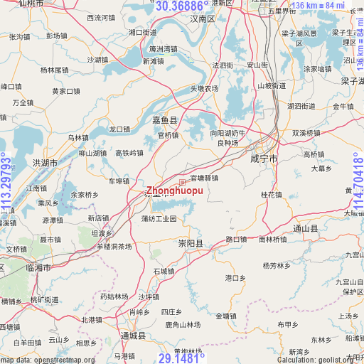
Zhonghuopu GPS coordinates[2]
29° 45' 37.224" North, 114° 0' 3.78" East
| Map corner | latitude | longitude |
|---|---|---|
| Upper-left | 30.36886°, | 113.29793° |
| Center: | 29.76034°, | 114.00105° |
| Lower-right: | 29.1481°, | 114.70418° |
| Map W x H: | 135.7×135.7 km | = 84.3×84.3mi |
| max Lat: | 53.31946° ⇑56.8% North |
| Zhonghuopu: | 29.76034° |
| min Lat: | ⇓43.2% South 18.22056° |
| min Long | Zhonghuopu | max Long |
| 75.07348° | 114.00105° | 134.28917° |
| W 48.6%⇐ | ⇒51.4% E |
Elevation
Elevation of Zhonghuopu is 53 m = 174 ft, and this is 431.8 m = 1417 ft below average elevation for this country.
| Max E: |
5622 m = 18445 ft | 69.7% |
| Avg. | 484.8 m = 1591 ft | |
| Zhonghuopu | 53 m = 174 ft | |
Min E: |
-3 m = -10 ft | 30.3% |
See also: China elevation on elevation.city.
Geographical zone
Zhonghuopu is located in North temperate zone (between Tropic of Cancer and the Arctic Circle). Distance of this Northern Tropic circle is 703.1 km =436.9 mi to South.| Distance of | km | miles | from Zhonghuopu |
|---|---|---|---|
| North Pole | 6698 | 4161.9 | to North |
| Arctic Circle | 4092.1 | 2542.7 | to North |
| Tropic Cancer | 703.1 | 436.9 | to South |
| Equator | 3309 | 2056.1 | to South |


Nearby cities:
15 places around Zhonghuopu: (largest is in red/bold)
• Baini
28 km =17.4 mi,  153°
153°
• Cha’anling
25.2 km =15.7 mi,  234°
234°
• Chebu
23.2 km =14.4 mi,  272°
272°
• Gaotieling
23 km =14.3 mi,  299°
299°
• Guanqiao
18.9 km =11.7 mi,  342°
342°
• Guantangyi
8.4 km =5.2 mi,  78°
78°
• Guihuaquan
25.6 km =15.9 mi,  208°
208°
• Lukou
28.9 km =18 mi,  136°
136°
• Puqi
12.4 km =7.7 mi,  246°
246°
• Shenshan
15.4 km =9.6 mi,  8°
8°
• Tiancheng
24.8 km =15.4 mi,  170°
170°
• Tingsiqiao
17.2 km =10.7 mi,  68°
68°
• Xiangyanghu
22.5 km =14 mi,  44°
44°
• Xinjie
28.2 km =17.5 mi,  358°
358°
• Yuyue
28.9 km =18 mi,  352°
352°
Sources, notices
• [Note1] Compared only with cities in China existing in our database
• [Src1] Map data: © OpenStreetMap contributors (CC-BY-SA)
• [Src2] Other city data from geonames.org with taken over terms of usage.
• [Src3] Geographical zone / Annual Mean Temperature by Robert A. Rohde @ Wikipedia
