Hongyi geodata
Hongyi (Jiangxi) is a seat of a fourth-order administrative division; located in China in Asia/Shanghai (GMT+8) time zone. In our database, there are 1268 cities with bigger population. Compared to other cities in China, 58.3% of cities are located further ↑North; 55.4% of cities are located further ←West and 65.2% of cities have higher elevation than Hongyi. Note1


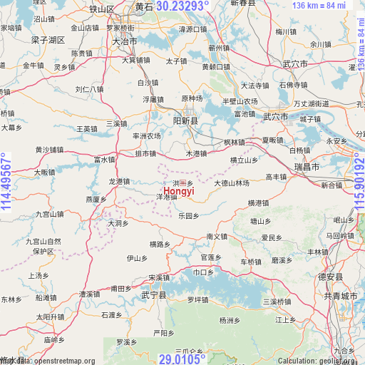
Hongyi GPS coordinates[2]
29° 37' 24.852" North, 115° 11' 55.644" East
| Map corner | latitude | longitude |
|---|---|---|
| Upper-left | 30.23293°, | 114.49567° |
| Center: | 29.62357°, | 115.19879° |
| Lower-right: | 29.0105°, | 115.90192° |
| Map W x H: | 135.9×135.9 km | = 84.4×84.4mi |
| max Lat: | 53.31946° ⇑58.3% North |
| Hongyi: | 29.62357° |
| min Lat: | ⇓41.7% South 18.22056° |
| min Long | Hongyi | max Long |
| 75.07348° | 115.19879° | 134.28917° |
| W 55.4%⇐ | ⇒44.6% E |
Elevation
Elevation of Hongyi is 72 m = 236 ft, and this is 412.8 m = 1354 ft below average elevation for this country.
| Max E: |
5622 m = 18445 ft | 65.2% |
| Avg. | 484.8 m = 1591 ft | |
| Hongyi | 72 m = 236 ft | |
Min E: |
-3 m = -10 ft | 34.8% |
See also: China elevation on elevation.city.
Geographical zone
Hongyi is located in North temperate zone (between Tropic of Cancer and the Arctic Circle). Distance of this Northern Tropic circle is 687.9 km =427.4 mi to South.| Distance of | km | miles | from Hongyi |
|---|---|---|---|
| North Pole | 6713.2 | 4171.4 | to North |
| Arctic Circle | 4107.3 | 2552.2 | to North |
| Tropic Cancer | 687.9 | 427.4 | to South |
| Equator | 3293.8 | 2046.7 | to South |


Nearby cities:
15 places around Hongyi: (largest is in red/bold)
• Fenglin
24.5 km =15.2 mi,  51°
51°
• Henglishan
24.3 km =15.1 mi,  69°
69°
• Henglu
24.7 km =15.3 mi,  200°
200°
• Huayuan
12.1 km =7.5 mi,  104°
104°
• Leyuan
12.3 km =7.6 mi,  170°
170°
• Longgang
24 km =14.9 mi,  270°
270°
• Luxi
21.3 km =13.2 mi, 170°
• Mugang
12 km =7.5 mi,  22°
22°
• Nanyi
23.1 km =14.4 mi,  147°
147°
• Neihu
22.6 km =14 mi,  62°
62°
• Paishi
17.7 km =11 mi,  308°
308°
• Quankou
21.6 km =13.4 mi,  230°
230°
• Xingguo
23.4 km =14.5 mi,  2°
2°
• Yanggang
7.8 km =4.8 mi, 229°
• Zhaochen
4.8 km =3 mi, 195°
Sources, notices
• [Note1] Compared only with cities in China existing in our database
• [Src1] Map data: © OpenStreetMap contributors (CC-BY-SA)
• [Src2] Other city data from geonames.org with taken over terms of usage.
• [Src3] Geographical zone / Annual Mean Temperature by Robert A. Rohde @ Wikipedia
