Yanggang geodata
Yanggang (Hubei) is a seat of a fourth-order administrative division; located in China in Asia/Shanghai (GMT+8) time zone. In our database, there are 1268 cities with bigger population. Compared to other cities in China, 58.8% of cities are located further ↑North; 55.1% of cities are located further ←West and 66.4% of cities have higher elevation than Yanggang. Note1


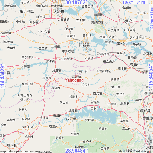
Yanggang GPS coordinates[2]
29° 34' 41.448" North, 115° 8' 14.676" East
| Map corner | latitude | longitude |
|---|---|---|
| Upper-left | 30.18782°, | 114.43429° |
| Center: | 29.57818°, | 115.13741° |
| Lower-right: | 28.96484°, | 115.84054° |
| Map W x H: | 136×136 km | = 84.5×84.5mi |
| max Lat: | 53.31946° ⇑58.8% North |
| Yanggang: | 29.57818° |
| min Lat: | ⇓41.2% South 18.22056° |
| min Long | Yanggang | max Long |
| 75.07348° | 115.13741° | 134.28917° |
| W 55.1%⇐ | ⇒44.9% E |
Elevation
Elevation of Yanggang is 67 m = 220 ft, and this is 417.8 m = 1371 ft below average elevation for this country.
| Max E: |
5622 m = 18445 ft | 66.4% |
| Avg. | 484.8 m = 1591 ft | |
| Yanggang | 67 m = 220 ft | |
Min E: |
-3 m = -10 ft | 33.6% |
See also: China elevation on elevation.city.
Geographical zone
Yanggang is located in North temperate zone (between Tropic of Cancer and the Arctic Circle). Distance of this Northern Tropic circle is 682.9 km =424.3 mi to South.| Distance of | km | miles | from Yanggang |
|---|---|---|---|
| North Pole | 6718.3 | 4174.6 | to North |
| Arctic Circle | 4112.4 | 2555.3 | to North |
| Tropic Cancer | 682.9 | 424.3 | to South |
| Equator | 3288.8 | 2043.6 | to South |


Nearby cities:
15 places around Yanggang: (largest is in red/bold)
• Dadong
20.7 km =12.9 mi,  241°
241°
• Guanlian
28.3 km =17.6 mi,  143°
143°
• Henglu
18.3 km =11.4 mi,  188°
188°
• Honggangshan
26.8 km =16.7 mi,  255°
255°
• Hongyi
7.8 km =4.8 mi,  49°
49°
• Huayuan
17.8 km =11.1 mi,  83°
83°
• Leyuan
10.6 km =6.6 mi,  132°
132°
• Longgang
18.8 km =11.7 mi,  286°
286°
• Luxi
18.4 km =11.4 mi,  149°
149°
• Mugang
19.3 km =12 mi,  33°
33°
• Nanyi
23.3 km =14.5 mi, 128°
• Paishi
17.9 km =11.1 mi,  333°
333°
• Quankou
13.8 km =8.6 mi,  230°
230°
• Yanxia
26.6 km =16.5 mi,  267°
267°
• Zhaochen
4.7 km =2.9 mi, 84°
Sources, notices
• [Note1] Compared only with cities in China existing in our database
• [Src1] Map data: © OpenStreetMap contributors (CC-BY-SA)
• [Src2] Other city data from geonames.org with taken over terms of usage.
• [Src3] Geographical zone / Annual Mean Temperature by Robert A. Rohde @ Wikipedia
