Chi’an geodata
Chi’an (Jiangxi) is a seat of a fourth-order administrative division; located in China in Asia/Shanghai (GMT+8) time zone. In our database, there are 1268 cities with bigger population. Compared to other cities in China, 68% of cities are located further ↑North; 56.2% of cities are located further ←West and 71.6% of cities have higher elevation than Chi’an. Note1


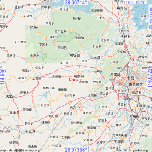
Chi’an GPS coordinates[2]
28° 41' 31.848" North, 115° 22' 8.832" East
| Map corner | latitude | longitude |
|---|---|---|
| Upper-left | 29.30714°, | 114.666° |
| Center: | 28.69218°, | 115.36912° |
| Lower-right: | 28.07358°, | 116.07225° |
| Map W x H: | 137.2×137.2 km | = 85.3×85.3mi |
| max Lat: | 53.31946° ⇑68% North |
| Chi’an: | 28.69218° |
| min Lat: | ⇓32% South 18.22056° |
| min Long | Chi’an | max Long |
| 75.07348° | 115.36912° | 134.28917° |
| W 56.2%⇐ | ⇒43.8% E |
Elevation
Elevation of Chi’an is 46 m = 151 ft, and this is 438.8 m = 1440 ft below average elevation for this country.
| Max E: |
5622 m = 18445 ft | 71.6% |
| Avg. | 484.8 m = 1591 ft | |
| Chi’an | 46 m = 151 ft | |
Min E: |
-3 m = -10 ft | 28.4% |
See also: China elevation on elevation.city.
Geographical zone
Chi’an is located in North temperate zone (between Tropic of Cancer and the Arctic Circle). Distance of this Northern Tropic circle is 584.4 km =363.1 mi to South.| Distance of | km | miles | from Chi’an |
|---|---|---|---|
| North Pole | 6816.8 | 4235.8 | to North |
| Arctic Circle | 4210.9 | 2616.5 | to North |
| Tropic Cancer | 584.4 | 363.1 | to South |
| Equator | 3190.3 | 1982.4 | to South |


Nearby cities:
15 places around Chi’an: (largest is in red/bold)
• Changbu
27.4 km =17 mi,  65°
65°
• Dacheng
22.5 km =14 mi,  139°
139°
• Dinghu
23.6 km =14.7 mi,  46°
46°
• Fengchuan
1.6 km =1 mi,  57°
57°
• Ganzhou
15.3 km =9.5 mi,  23°
23°
• Huibu
18.7 km =11.6 mi,  281°
281°
• Leigongjian
21.8 km =13.5 mi,  352°
352°
• Qiaole
19.7 km =12.2 mi,  105°
105°
• Shibi
19.9 km =12.4 mi,  77°
77°
• Shuangxi
19.1 km =11.9 mi, 354°
• Shuikou
22.9 km =14.2 mi,  340°
340°
• Songbu
12.9 km =8 mi, 69°
• Wangjiaxu
18 km =11.2 mi,  198°
198°
• Wuqiao
17.2 km =10.7 mi,  226°
226°
• Xiangfu
24.9 km =15.5 mi,  166°
166°
Sources, notices
• [Note1] Compared only with cities in China existing in our database
• [Src1] Map data: © OpenStreetMap contributors (CC-BY-SA)
• [Src2] Other city data from geonames.org with taken over terms of usage.
• [Src3] Geographical zone / Annual Mean Temperature by Robert A. Rohde @ Wikipedia
