Dacheng geodata
Dacheng (Jiangxi) is a seat of a fourth-order administrative division; located in China in Asia/Shanghai (GMT+8) time zone. In our database, there are 1268 cities with bigger population. Compared to other cities in China, 69.4% of cities are located further ↑North; 57.1% of cities are located further ←West and 73.3% of cities have higher elevation than Dacheng. Note1


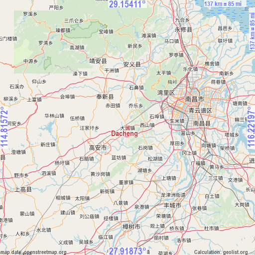
Dacheng GPS coordinates[2]
28° 32' 17.628" North, 115° 31' 7.824" East
| Map corner | latitude | longitude |
|---|---|---|
| Upper-left | 29.15411°, | 114.81572° |
| Center: | 28.53823°, | 115.51884° |
| Lower-right: | 27.91873°, | 116.22197° |
| Map W x H: | 137.4×137.4 km | = 85.4×85.4mi |
| max Lat: | 53.31946° ⇑69.4% North |
| Dacheng: | 28.53823° |
| min Lat: | ⇓30.6% South 18.22056° |
| min Long | Dacheng | max Long |
| 75.07348° | 115.51884° | 134.28917° |
| W 57.1%⇐ | ⇒42.9% E |
Elevation
Elevation of Dacheng is 41 m = 135 ft, and this is 443.8 m = 1456 ft below average elevation for this country.
| Max E: |
5622 m = 18445 ft | 73.3% |
| Avg. | 484.8 m = 1591 ft | |
| Dacheng | 41 m = 135 ft | |
Min E: |
-3 m = -10 ft | 26.7% |
See also: China elevation on elevation.city.
Geographical zone
Dacheng is located in North temperate zone (between Tropic of Cancer and the Arctic Circle). Distance of this Northern Tropic circle is 567.2 km =352.4 mi to South.| Distance of | km | miles | from Dacheng |
|---|---|---|---|
| North Pole | 6833.9 | 4246.4 | to North |
| Arctic Circle | 4228 | 2627.2 | to North |
| Tropic Cancer | 567.2 | 352.4 | to South |
| Equator | 3173.2 | 1971.7 | to South |


Nearby cities:
15 places around Dacheng: (largest is in red/bold)
• Chi’an
22.5 km =14 mi,  319°
319°
• Fengchuan
22.3 km =13.9 mi, 323°
• Heling
23.1 km =14.4 mi,  207°
207°
• Huangcheng
20.2 km =12.6 mi,  168°
168°
• Junyang
20.1 km =12.5 mi,  227°
227°
• Lanfangzhen
16.6 km =10.3 mi,  197°
197°
• Liuhu
21.3 km =13.2 mi,  110°
110°
• Qiaole
12.6 km =7.8 mi,  20°
20°
• Shibi
21.9 km =13.6 mi,  12°
12°
• Shigang
14.8 km =9.2 mi,  135°
135°
• Songbu
21.8 km =13.5 mi,  353°
353°
• Songhu
21.9 km =13.6 mi, 143°
• Wangjiaxu
20.5 km =12.7 mi,  270°
270°
• Xiangfu
11.2 km =7 mi, 230°
• Xishan
10.5 km =6.5 mi,  81°
81°
Sources, notices
• [Note1] Compared only with cities in China existing in our database
• [Src1] Map data: © OpenStreetMap contributors (CC-BY-SA)
• [Src2] Other city data from geonames.org with taken over terms of usage.
• [Src3] Geographical zone / Annual Mean Temperature by Robert A. Rohde @ Wikipedia
