Niaojin geodata
Niaojin (Hubei) is a seat of a fourth-order administrative division; located in China in Asia/Shanghai (GMT+8) time zone. In our database, there are 1268 cities with bigger population. Compared to other cities in China, 50.8% of cities are located further ↑North; 51% of cities are located further →East and 80.2% of cities have higher elevation than Niaojin. Note1


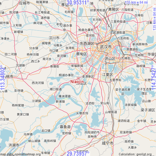
Niaojin GPS coordinates[2]
30° 20' 53.592" North, 114° 3' 4.104" East
| Map corner | latitude | longitude |
|---|---|---|
| Upper-left | 30.95311°, | 113.34802° |
| Center: | 30.34822°, | 114.05114° |
| Lower-right: | 29.73957°, | 114.75427° |
| Map W x H: | 134.9×134.9 km | = 83.8×83.8mi |
| max Lat: | 53.31946° ⇑50.8% North |
| Niaojin: | 30.34822° |
| min Lat: | ⇓49.2% South 18.22056° |
| min Long | Niaojin | max Long |
| 75.07348° | 114.05114° | 134.28917° |
| W 49%⇐ | ⇒51% E |
Elevation
Elevation of Niaojin is 26 m = 85 ft, and this is 458.8 m = 1505 ft below average elevation for this country.
| Max E: |
5622 m = 18445 ft | 80.2% |
| Avg. | 484.8 m = 1591 ft | |
| Niaojin | 26 m = 85 ft | |
Min E: |
-3 m = -10 ft | 19.8% |
See also: China elevation on elevation.city.
Geographical zone
Niaojin is located in North temperate zone (between Tropic of Cancer and the Arctic Circle). Distance of this Northern Tropic circle is 768.5 km =477.5 mi to South.| Distance of | km | miles | from Niaojin |
|---|---|---|---|
| North Pole | 6632.7 | 4121.4 | to North |
| Arctic Circle | 4026.8 | 2502.1 | to North |
| Tropic Cancer | 768.5 | 477.5 | to South |
| Equator | 3374.4 | 2096.8 | to South |


Nearby cities:
15 places around Niaojin: (largest is in red/bold)
• Daji
17.9 km =11.1 mi,  357°
357°
• Dengnan
8.7 km =5.4 mi,  234°
234°
• Dongchengyuan
13.6 km =8.5 mi,  269°
269°
• Fasi
23.6 km =14.7 mi,  154°
154°
• Hannan
21.9 km =13.6 mi,  245°
245°
• Jinkou
7.6 km =4.7 mi,  96°
96°
• Junshan
7 km =4.3 mi,  25°
25°
• Paizhou
19.4 km =12.1 mi,  217°
217°
• Sheshan
11.9 km =7.4 mi,  338°
338°
• Suohe
24.3 km =15.1 mi,  322°
322°
• Xintan
25.3 km =15.7 mi, 217°
• Yong’an
17.2 km =10.7 mi, 317°
• Yuxian
20.9 km =13 mi, 340°
• Zhengdian
19.2 km =11.9 mi,  94°
94°
• Zhuru
23.1 km =14.4 mi,  296°
296°
Sources, notices
• [Note1] Compared only with cities in China existing in our database
• [Src1] Map data: © OpenStreetMap contributors (CC-BY-SA)
• [Src2] Other city data from geonames.org with taken over terms of usage.
• [Src3] Geographical zone / Annual Mean Temperature by Robert A. Rohde @ Wikipedia
