Dongshan geodata
Dongshan (Hubei) is a seat of a fourth-order administrative division; located in China in Asia/Shanghai (GMT+8) time zone. In our database, there are 1268 cities with bigger population. Compared to other cities in China, 52.7% of cities are located further ↓South; 51.3% of cities are located further →East and 79.8% of cities have higher elevation than Dongshan. Note1


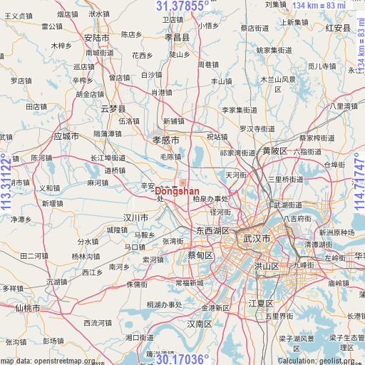
Dongshan GPS coordinates[2]
30° 46' 34.86" North, 114° 0' 51.624" East
| Map corner | latitude | longitude |
|---|---|---|
| Upper-left | 31.37855°, | 113.31122° |
| Center: | 30.77635°, | 114.01434° |
| Lower-right: | 30.17036°, | 114.71747° |
| Map W x H: | 134.3×134.3 km | = 83.5×83.5mi |
| max Lat: | 53.31946° ⇑47.3% North |
| Dongshan: | 30.77635° |
| min Lat: | ⇓52.7% South 18.22056° |
| min Long | Dongshan | max Long |
| 75.07348° | 114.01434° | 134.28917° |
| W 48.7%⇐ | ⇒51.3% E |
Elevation
Elevation of Dongshan is 27 m = 89 ft, and this is 457.8 m = 1502 ft below average elevation for this country.
| Max E: |
5622 m = 18445 ft | 79.8% |
| Avg. | 484.8 m = 1591 ft | |
| Dongshan | 27 m = 89 ft | |
Min E: |
-3 m = -10 ft | 20.2% |
See also: China elevation on elevation.city.
Geographical zone
Dongshan is located in North temperate zone (between Tropic of Cancer and the Arctic Circle). Distance of this Northern Tropic circle is 816.1 km =507.1 mi to South.| Distance of | km | miles | from Dongshan |
|---|---|---|---|
| North Pole | 6585.1 | 4091.8 | to North |
| Arctic Circle | 3979.2 | 2472.6 | to North |
| Tropic Cancer | 816.1 | 507.1 | to South |
| Equator | 3422 | 2126.3 | to South |


Nearby cities:
15 places around Dongshan: (largest is in red/bold)
• Guangchang
19.1 km =11.9 mi,  329°
329°
• Hebaohu
9.3 km =5.8 mi,  205°
205°
• Maochen
10.8 km =6.7 mi,  335°
335°
• Maomiaoji
11.1 km =6.9 mi,  117°
117°
• Minji
13.2 km =8.2 mi,  56°
56°
• Mintian
17.3 km =10.7 mi,  126°
126°
• Sandian
19.1 km =11.9 mi,  136°
136°
• Wolong
18.3 km =11.4 mi,  321°
321°
• Xiaogan
18.9 km =11.7 mi, 332°
• Xiaxindian
18.2 km =11.3 mi,  290°
290°
• Xingou
15.7 km =9.8 mi,  191°
191°
• Xinhe
12.4 km =7.7 mi,  218°
218°
• Xinhua
18.4 km =11.4 mi, 326°
• Xin’andu
9.1 km =5.7 mi,  246°
246°
• Zoumaling
13.7 km =8.5 mi,  179°
179°
Sources, notices
• [Note1] Compared only with cities in China existing in our database
• [Src1] Map data: © OpenStreetMap contributors (CC-BY-SA)
• [Src2] Other city data from geonames.org with taken over terms of usage.
• [Src3] Geographical zone / Annual Mean Temperature by Robert A. Rohde @ Wikipedia
