Wangdian geodata
Wangdian (Hubei) is a seat of a fourth-order administrative division; located in China in Asia/Shanghai (GMT+8) time zone. In our database, there are 1268 cities with bigger population. Compared to other cities in China, 50.4% of cities are located further ↓South; 51.5% of cities are located further ←West and 74.1% of cities have higher elevation than Wangdian. Note1


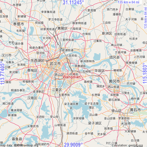
Wangdian GPS coordinates[2]
30° 30' 30.816" North, 114° 28' 37.812" East
| Map corner | latitude | longitude |
|---|---|---|
| Upper-left | 31.11245°, | 113.77405° |
| Center: | 30.50856°, | 114.47717° |
| Lower-right: | 29.9009°, | 115.1803° |
| Map W x H: | 134.7×134.7 km | = 83.7×83.7mi |
| max Lat: | 53.31946° ⇑49.6% North |
| Wangdian: | 30.50856° |
| min Lat: | ⇓50.4% South 18.22056° |
| min Long | Wangdian | max Long |
| 75.07348° | 114.47717° | 134.28917° |
| W 51.5%⇐ | ⇒48.5% E |
Elevation
Elevation of Wangdian is 39 m = 128 ft, and this is 445.8 m = 1463 ft below average elevation for this country.
| Max E: |
5622 m = 18445 ft | 74.1% |
| Avg. | 484.8 m = 1591 ft | |
| Wangdian | 39 m = 128 ft | |
Min E: |
-3 m = -10 ft | 25.9% |
See also: China elevation on elevation.city.
Geographical zone
Wangdian is located in North temperate zone (between Tropic of Cancer and the Arctic Circle). Distance of this Northern Tropic circle is 786.3 km =488.6 mi to South.| Distance of | km | miles | from Wangdian |
|---|---|---|---|
| North Pole | 6614.8 | 4110.2 | to North |
| Arctic Circle | 4008.9 | 2491 | to North |
| Tropic Cancer | 786.3 | 488.6 | to South |
| Equator | 3392.2 | 2107.8 | to South |


Nearby cities:
15 places around Wangdian: (largest is in red/bold)
• Baiyushan
10.7 km =6.6 mi,  5°
5°
• Dujiajing
17.2 km =10.7 mi,  353°
353°
• Gedian
13.6 km =8.5 mi,  78°
78°
• Guanshan
7.1 km =4.4 mi,  268°
268°
• Guanshang
18 km =11.2 mi,  23°
23°
• Heping
15.9 km =9.9 mi,  327°
327°
• Hongqi
11.7 km =7.3 mi,  338°
338°
• Huashan
5.2 km =3.2 mi,  42°
42°
• Liufang
7.6 km =4.7 mi,  201°
201°
• Miaoling
14.8 km =9.2 mi,  116°
116°
• Shizishan
14.4 km =8.9 mi,  259°
259°
• Shuangliu
18.3 km =11.4 mi,  59°
59°
• Tianxing
18.8 km =11.7 mi, 341°
• Wudong
8.5 km =5.3 mi, 345°
• Zuoling
12.1 km =7.5 mi, 77°
Sources, notices
• [Note1] Compared only with cities in China existing in our database
• [Src1] Map data: © OpenStreetMap contributors (CC-BY-SA)
• [Src2] Other city data from geonames.org with taken over terms of usage.
• [Src3] Geographical zone / Annual Mean Temperature by Robert A. Rohde @ Wikipedia
