Jangra geodata
Jangra (Tibet) is a seat of a fourth-order administrative division; located in China in Asia/Shanghai (GMT+8) time zone. In our database, there are 1268 cities with bigger population. Compared to other cities in China, 66.3% of cities are located further ↑North; 97.4% of cities are located further →East and 98.7% of cities have lower elevation than Jangra. Note1


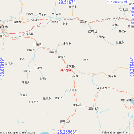
Jangra GPS coordinates[2]
28° 54' 10.764" North, 89° 34' 23.916" East
| Map corner | latitude | longitude |
|---|---|---|
| Upper-left | 29.5167°, | 88.87019° |
| Center: | 28.90299°, | 89.57331° |
| Lower-right: | 28.28563°, | 90.27644° |
| Map W x H: | 136.9×136.9 km | = 85.1×85.1mi |
| max Lat: | 53.31946° ⇑66.3% North |
| Jangra: | 28.90299° |
| min Lat: | ⇓33.7% South 18.22056° |
| min Long | Jangra | max Long |
| 75.07348° | 89.57331° | 134.28917° |
| W 2.6%⇐ | ⇒97.4% E |
Elevation
Elevation of Jangra is 4024 m = 13202 ft, and this is 3539.2 m = 11612 ft above average elevation for this country.
| Max E: |
5622 m = 18445 ft | 1.3% |
| Jangra | 4024 m 13202 ft | |
| Avg. | 484.8 m = 1591 ft | |
Min E: |
-3 m = -10 ft | 98.7% |
See also: China elevation on elevation.city.
Geographical zone
Jangra is located in North temperate zone (between Tropic of Cancer and the Arctic Circle). Distance of this Northern Tropic circle is 607.8 km =377.7 mi to South.| Distance of | km | miles | from Jangra |
|---|---|---|---|
| North Pole | 6793.4 | 4221.2 | to North |
| Arctic Circle | 4187.5 | 2602 | to North |
| Tropic Cancer | 607.8 | 377.7 | to South |
| Equator | 3213.7 | 1996.9 | to South |


Nearby cities:
15 places around Jangra: (largest is in red/bold)
• Cheren
12.9 km =8 mi,  110°
110°
• Dazi
22.8 km =14.2 mi,  324°
324°
• Jiangzi
3.2 km =2 mi,  53°
53°
• Kangzhuo
7.7 km =4.8 mi,  257°
257°
• Kardoi
24.5 km =15.2 mi,  0°
0°
• Karmai
26.9 km =16.7 mi,  343°
343°
• Nanni
11.6 km =7.2 mi,  139°
139°
• Narong
27 km =16.8 mi,  9°
9°
• Niandui
8.6 km =5.3 mi,  100°
100°
• Qiangdui
28.9 km =18 mi, 315°
• Rasog
21.4 km =13.3 mi, 318°
• Rixing
29.1 km =18.1 mi,  269°
269°
• Zangka
11.9 km =7.4 mi,  334°
334°
• Zhongzi
17.3 km =10.7 mi, 320°
• Zijin
4.3 km =2.7 mi,  296°
296°
Sources, notices
• [Note1] Compared only with cities in China existing in our database
• [Src1] Map data: © OpenStreetMap contributors (CC-BY-SA)
• [Src2] Other city data from geonames.org with taken over terms of usage.
• [Src3] Geographical zone / Annual Mean Temperature by Robert A. Rohde @ Wikipedia
