Qinggou geodata
Qinggou (Jiangsu) is a seat of a fourth-order administrative division; located in China in Asia/Shanghai (GMT+8) time zone. In our database, there are 1268 cities with bigger population. Compared to other cities in China, 68.7% of cities are located further ↓South; 78.2% of cities are located further ←West and 97.2% of cities have higher elevation than Qinggou. Note1


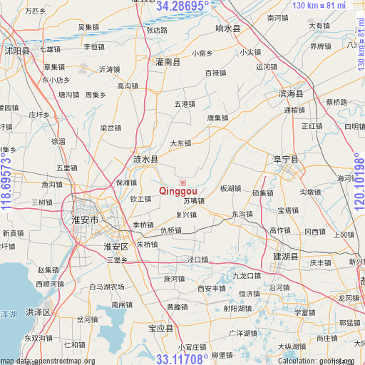
Qinggou GPS coordinates[2]
33° 42' 14.436" North, 119° 23' 55.86" East
| Map corner | latitude | longitude |
|---|---|---|
| Upper-left | 34.28695°, | 118.69573° |
| Center: | 33.70401°, | 119.39885° |
| Lower-right: | 33.11708°, | 120.10198° |
| Map W x H: | 130.1×130.1 km | = 80.8×80.8mi |
| max Lat: | 53.31946° ⇑31.3% North |
| Qinggou: | 33.70401° |
| min Lat: | ⇓68.7% South 18.22056° |
| min Long | Qinggou | max Long |
| 75.07348° | 119.39885° | 134.28917° |
| W 78.2%⇐ | ⇒21.8% E |
Elevation
Elevation of Qinggou is 5 m = 16 ft, and this is 479.8 m = 1574 ft below average elevation for this country.
| Max E: |
5622 m = 18445 ft | 97.2% |
| Avg. | 484.8 m = 1591 ft | |
| Qinggou | 5 m = 16 ft | |
Min E: |
-3 m = -10 ft | 2.8% |
See also: China elevation on elevation.city.
Geographical zone
Qinggou is located in North temperate zone (between Tropic of Cancer and the Arctic Circle). Distance of this Northern Tropic circle is 1141.6 km =709.4 mi to South.| Distance of | km | miles | from Qinggou |
|---|---|---|---|
| North Pole | 6259.5 | 3889.5 | to North |
| Arctic Circle | 3653.6 | 2270.2 | to North |
| Tropic Cancer | 1141.6 | 709.4 | to South |
| Equator | 3747.5 | 2328.6 | to South |


Nearby cities:
15 places around Qinggou: (largest is in red/bold)
• Bailu
40.5 km =25.2 mi,  16°
16°
• Baoying
53.4 km =33.2 mi,  188°
188°
• Chenji
53.3 km =33.1 mi,  358°
358°
• Dongkan
51.7 km =32.1 mi,  50°
50°
• Gaogou
39.9 km =24.8 mi,  330°
330°
• Huai'an
37.4 km =23.2 mi,  249°
249°
• Huayuan
41.5 km =25.8 mi,  6°
6°
• Liji
46.6 km =29 mi,  343°
343°
• Machang
55 km =34.2 mi,  320°
320°
• Mengxingzhuang
55 km =34.2 mi, 342°
• Sankou
53.9 km =33.5 mi, 8°
• Xiaojian
53.1 km =33 mi,  25°
25°
• Yitao
50.4 km =31.3 mi, 326°
• Yunhe
51.4 km =31.9 mi, 34°
• Zhangji
44.9 km =27.9 mi, 31°
Sources, notices
• [Note1] Compared only with cities in China existing in our database
• [Src1] Map data: © OpenStreetMap contributors (CC-BY-SA)
• [Src2] Other city data from geonames.org with taken over terms of usage.
• [Src3] Geographical zone / Annual Mean Temperature by Robert A. Rohde @ Wikipedia
