Huai'an geodata
Huai'an (Jiangsu) is a populated place; located in China in Asia/Shanghai (GMT+8) time zone. With population of 555,230 people, there are 116 cities with bigger population in this country. Compared to other cities in China, 68.3% of cities are located further ↓South; 76.1% of cities are located further ←West and 86.2% of cities have higher elevation than Huai'an. Note1


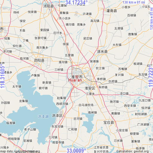
Huai'an GPS coordinates[2]
33° 35' 18.996" North, 119° 1' 9.012" East
| Map corner | latitude | longitude |
|---|---|---|
| Upper-left | 34.17234°, | 118.31605° |
| Center: | 33.58861°, | 119.01917° |
| Lower-right: | 33.0009°, | 119.7223° |
| Map W x H: | 130.3×130.3 km | = 81×81mi |
| max Lat: | 53.31946° ⇑31.7% North |
| Huai'an: | 33.58861° |
| min Lat: | ⇓68.3% South 18.22056° |
| min Long | Huai'an | max Long |
| 75.07348° | 119.01917° | 134.28917° |
| W 76.1%⇐ | ⇒23.9% E |
Elevation
Elevation of Huai'an is 14 m = 46 ft, and this is 470.8 m = 1545 ft below average elevation for this country.
| Max E: |
5622 m = 18445 ft | 86.2% |
| Avg. | 484.8 m = 1591 ft | |
| Huai'an | 14 m = 46 ft | |
Min E: |
-3 m = -10 ft | 13.8% |
See also: Huai'an elevation on elevation.city.
Geographical zone
Huai'an is located in North temperate zone (between Tropic of Cancer and the Arctic Circle). Distance of this Northern Tropic circle is 1128.8 km =701.4 mi to South.| Distance of | km | miles | from Huai'an |
|---|---|---|---|
| North Pole | 6272.4 | 3897.5 | to North |
| Arctic Circle | 3666.5 | 2278.3 | to North |
| Tropic Cancer | 1128.8 | 701.4 | to South |
| Equator | 3734.7 | 2320.6 | to South |


Nearby cities:
15 places around Huai'an: (largest is in red/bold)
• Bailu
69.5 km =43.2 mi,  41°
41°
• Baoying
48.2 km =30 mi,  146°
146°
• Gaogou
50.2 km =31.2 mi,  18°
18°
• Huayuan
67.1 km =41.7 mi, 36°
• Huying
69.7 km =43.3 mi, 145°
• Liheng
60.6 km =37.7 mi,  2°
2°
• Liji
61.3 km =38.1 mi, 20°
• Machang
55 km =34.2 mi,  359°
359°
• Mengxingzhuang
67.7 km =42.1 mi, 15°
• Qinggou
37.4 km =23.2 mi,  69°
69°
• Shucheng
63.2 km =39.3 mi,  339°
339°
• Tangjian
60.6 km =37.7 mi, 358°
• Wuji
68.1 km =42.3 mi, 1°
• Yitao
55.5 km =34.5 mi,  7°
7°
• Zhongxing
34 km =21.1 mi,  292°
292°
Sources, notices
• [Note1] Compared only with cities in China existing in our database
• [Src1] Map data: © OpenStreetMap contributors (CC-BY-SA)
• [Src2] Other city data from geonames.org with taken over terms of usage.
• [Src3] Geographical zone / Annual Mean Temperature by Robert A. Rohde @ Wikipedia
