Namaqie geodata
Namaqie (Tibet) is a seat of a fourth-order administrative division; located in China in Asia/Shanghai (GMT+8) time zone. In our database, there are 1268 cities with bigger population. Compared to other cities in China, 58.6% of cities are located further ↓South; 96.9% of cities are located further →East and 99.6% of cities have lower elevation than Namaqie. Note1


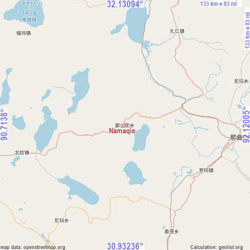
Namaqie GPS coordinates[2]
31° 32' 0.852" North, 91° 25' 0.912" East
| Map corner | latitude | longitude |
|---|---|---|
| Upper-left | 32.13094°, | 90.7138° |
| Center: | 31.53357°, | 91.41692° |
| Lower-right: | 30.93236°, | 92.12005° |
| Map W x H: | 133.3×133.3 km | = 82.8×82.8mi |
| max Lat: | 53.31946° ⇑41.4% North |
| Namaqie: | 31.53357° |
| min Lat: | ⇓58.6% South 18.22056° |
| min Long | Namaqie | max Long |
| 75.07348° | 91.41692° | 134.28917° |
| W 3.1%⇐ | ⇒96.9% E |
Elevation
Elevation of Namaqie is 4571 m = 14997 ft, and this is 4086.2 m = 13406 ft above average elevation for this country.
| Max E: |
5622 m = 18445 ft | 0.40000000000001% |
| Namaqie | 4571 m 14997 ft | |
| Avg. | 484.8 m = 1591 ft | |
Min E: |
-3 m = -10 ft | 99.6% |
See also: China elevation on elevation.city.
Geographical zone
Namaqie is located in North temperate zone (between Tropic of Cancer and the Arctic Circle). Distance of this Northern Tropic circle is 900.3 km =559.4 mi to South.| Distance of | km | miles | from Namaqie |
|---|---|---|---|
| North Pole | 6500.9 | 4039.5 | to North |
| Arctic Circle | 3895 | 2420.2 | to North |
| Tropic Cancer | 900.3 | 559.4 | to South |
| Equator | 3506.2 | 2178.7 | to South |


Nearby cities:
15 places around Namaqie: (largest is in red/bold)
• Beila
57.7 km =35.9 mi,  255°
255°
• Dagsar
87.6 km =54.4 mi,  109°
109°
• Golug
80.6 km =50.1 mi,  166°
166°
• Jiaqiong
80.8 km =50.2 mi,  279°
279°
• Kormang
97.3 km =60.5 mi,  79°
79°
• Nagqu
57.4 km =35.7 mi,  104°
104°
• Nagqu
61 km =37.9 mi, 95°
• Nyima
61.1 km =38 mi,  213°
213°
• Nyima
83.1 km =51.6 mi,  72°
72°
• Pagnag
85.6 km =53.2 mi,  16°
16°
• Qiangma
73.1 km =45.4 mi,  312°
312°
• Qinglung
82.4 km =51.2 mi,  239°
239°
• Segong
100.7 km =62.6 mi,  41°
41°
• Xomong
61.9 km =38.5 mi,  156°
156°
• Zaring
57.3 km =35.6 mi,  28°
28°
Sources, notices
• [Note1] Compared only with cities in China existing in our database
• [Src1] Map data: © OpenStreetMap contributors (CC-BY-SA)
• [Src2] Other city data from geonames.org with taken over terms of usage.
• [Src3] Geographical zone / Annual Mean Temperature by Robert A. Rohde @ Wikipedia
