Dagsar geodata
Dagsar (Tibet) is a seat of a fourth-order administrative division; located in China in Asia/Shanghai (GMT+8) time zone. In our database, there are 1268 cities with bigger population. Compared to other cities in China, 56.8% of cities are located further ↓South; 96.7% of cities are located further →East and 99.5% of cities have lower elevation than Dagsar. Note1


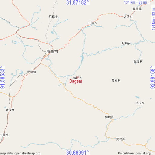
Dagsar GPS coordinates[2]
31° 16' 22.008" North, 92° 17' 18.42" East
| Map corner | latitude | longitude |
|---|---|---|
| Upper-left | 31.87182°, | 91.58533° |
| Center: | 31.27278°, | 92.28845° |
| Lower-right: | 30.66991°, | 92.99158° |
| Map W x H: | 133.6×133.6 km | = 83×83mi |
| max Lat: | 53.31946° ⇑43.2% North |
| Dagsar: | 31.27278° |
| min Lat: | ⇓56.8% South 18.22056° |
| min Long | Dagsar | max Long |
| 75.07348° | 92.28845° | 134.28917° |
| W 3.3%⇐ | ⇒96.7% E |
Elevation
Elevation of Dagsar is 4455 m = 14616 ft, and this is 3970.2 m = 13026 ft above average elevation for this country.
| Max E: |
5622 m = 18445 ft | 0.5% |
| Dagsar | 4455 m 14616 ft | |
| Avg. | 484.8 m = 1591 ft | |
Min E: |
-3 m = -10 ft | 99.5% |
See also: China elevation on elevation.city.
Geographical zone
Dagsar is located in North temperate zone (between Tropic of Cancer and the Arctic Circle). Distance of this Northern Tropic circle is 871.3 km =541.4 mi to South.| Distance of | km | miles | from Dagsar |
|---|---|---|---|
| North Pole | 6529.9 | 4057.5 | to North |
| Arctic Circle | 3924 | 2438.3 | to North |
| Tropic Cancer | 871.3 | 541.4 | to South |
| Equator | 3477.2 | 2160.6 | to South |


Nearby cities:
15 places around Dagsar: (largest is in red/bold)
• Cola
58.4 km =36.3 mi,  111°
111°
• Daqian
68.6 km =42.6 mi,  39°
39°
• Golug
80.5 km =50 mi,  232°
232°
• Kormang
49.1 km =30.5 mi,  15°
15°
• Lingti
44.4 km =27.6 mi,  142°
142°
• Lomai
33.1 km =20.6 mi,  93°
93°
• Nagqu
30.7 km =19.1 mi,  298°
298°
• Nagqu
31.6 km =19.6 mi,  315°
315°
• Nyima
51.8 km =32.2 mi,  54°
54°
• Nyima
54.2 km =33.7 mi,  356°
356°
• Sexiong
53.8 km =33.4 mi,  74°
74°
• Xagqu
78.3 km =48.7 mi, 40°
• Xarma
64.7 km =40.2 mi, 144°
• Xomong
64.7 km =40.2 mi,  244°
244°
• Zangbi
67.8 km =42.1 mi,  173°
173°
Sources, notices
• [Note1] Compared only with cities in China existing in our database
• [Src1] Map data: © OpenStreetMap contributors (CC-BY-SA)
• [Src2] Other city data from geonames.org with taken over terms of usage.
• [Src3] Geographical zone / Annual Mean Temperature by Robert A. Rohde @ Wikipedia
