Xomong geodata
Xomong (Tibet) is a seat of a fourth-order administrative division; located in China in Asia/Shanghai (GMT+8) time zone. In our database, there are 1268 cities with bigger population. Compared to other cities in China, 55% of cities are located further ↓South; 96.9% of cities are located further →East and 99.8% of cities have lower elevation than Xomong. Note1


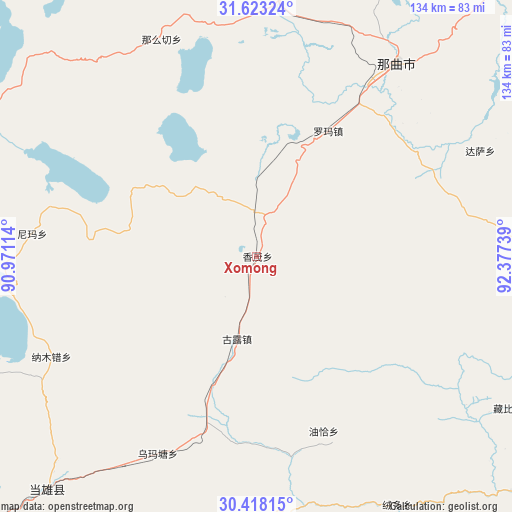
Xomong GPS coordinates[2]
31° 1' 21.36" North, 91° 40' 27.336" East
| Map corner | latitude | longitude |
|---|---|---|
| Upper-left | 31.62324°, | 90.97114° |
| Center: | 31.0226°, | 91.67426° |
| Lower-right: | 30.41815°, | 92.37739° |
| Map W x H: | 134×134 km | = 83.3×83.3mi |
| max Lat: | 53.31946° ⇑45% North |
| Xomong: | 31.0226° |
| min Lat: | ⇓55% South 18.22056° |
| min Long | Xomong | max Long |
| 75.07348° | 91.67426° | 134.28917° |
| W 3.1%⇐ | ⇒96.9% E |
Elevation
Elevation of Xomong is 4676 m = 15341 ft, and this is 4191.2 m = 13751 ft above average elevation for this country.
| Max E: |
5622 m = 18445 ft | 0.2% |
| Xomong | 4676 m 15341 ft | |
| Avg. | 484.8 m = 1591 ft | |
Min E: |
-3 m = -10 ft | 99.8% |
See also: China elevation on elevation.city.
Geographical zone
Xomong is located in North temperate zone (between Tropic of Cancer and the Arctic Circle). Distance of this Northern Tropic circle is 843.5 km =524.1 mi to South.| Distance of | km | miles | from Xomong |
|---|---|---|---|
| North Pole | 6557.7 | 4074.8 | to North |
| Arctic Circle | 3951.8 | 2455.5 | to North |
| Tropic Cancer | 843.5 | 524.1 | to South |
| Equator | 3449.4 | 2143.4 | to South |


Nearby cities:
15 places around Xomong: (largest is in red/bold)
• Beila
90.8 km =56.4 mi,  297°
297°
• Codoi
93.5 km =58.1 mi,  130°
130°
• Dagsar
64.7 km =40.2 mi,  64°
64°
• Golug
22.1 km =13.7 mi,  193°
193°
• Lingti
86.2 km =53.6 mi,  94°
94°
• Lomai
95.1 km =59.1 mi,  74°
74°
• Nagqu
52.6 km =32.7 mi,  36°
36°
• Nagqu
62.3 km =38.7 mi, 35°
• Namaqie
61.9 km =38.5 mi,  336°
336°
• Nyima
59 km =36.7 mi,  275°
275°
• Nyima
98.7 km =61.3 mi,  33°
33°
• Qinglung
97.2 km =60.4 mi, 279°
• Rongdoi
74 km =46 mi,  151°
151°
• Yoiqag
49 km =30.4 mi,  158°
158°
• Zangbi
77 km =47.8 mi,  120°
120°
Sources, notices
• [Note1] Compared only with cities in China existing in our database
• [Src1] Map data: © OpenStreetMap contributors (CC-BY-SA)
• [Src2] Other city data from geonames.org with taken over terms of usage.
• [Src3] Geographical zone / Annual Mean Temperature by Robert A. Rohde @ Wikipedia
