Nyima geodata
Nyima (Tibet) is a seat of a fourth-order administrative division; located in China in Asia/Shanghai (GMT+8) time zone. In our database, there are 1268 cities with bigger population. Compared to other cities in China, 59.9% of cities are located further ↓South; 96.8% of cities are located further →East and 99.9% of cities have lower elevation than Nyima. Note1


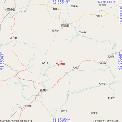
Nyima GPS coordinates[2]
31° 45' 33.408" North, 92° 15' 12.78" East
| Map corner | latitude | longitude |
|---|---|---|
| Upper-left | 32.35519°, | 91.55043° |
| Center: | 31.75928°, | 92.25355° |
| Lower-right: | 31.15951°, | 92.95668° |
| Map W x H: | 132.9×132.9 km | = 82.6×82.6mi |
| max Lat: | 53.31946° ⇑40.1% North |
| Nyima: | 31.75928° |
| min Lat: | ⇓59.9% South 18.22056° |
| min Long | Nyima | max Long |
| 75.07348° | 92.25355° | 134.28917° |
| W 3.2%⇐ | ⇒96.8% E |
Elevation
Elevation of Nyima is 4737 m = 15541 ft, and this is 4252.2 m = 13951 ft above average elevation for this country.
| Max E: |
5622 m = 18445 ft | 0.099999999999994% |
| Nyima | 4737 m 15541 ft | |
| Avg. | 484.8 m = 1591 ft | |
Min E: |
-3 m = -10 ft | 99.9% |
See also: China elevation on elevation.city.
Geographical zone
Nyima is located in North temperate zone (between Tropic of Cancer and the Arctic Circle). Distance of this Northern Tropic circle is 925.4 km =575 mi to South.| Distance of | km | miles | from Nyima |
|---|---|---|---|
| North Pole | 6475.8 | 4023.9 | to North |
| Arctic Circle | 3869.9 | 2404.6 | to North |
| Tropic Cancer | 925.4 | 575 | to South |
| Equator | 3531.3 | 2194.2 | to South |


Nearby cities:
15 places around Nyima: (largest is in red/bold)
• Dagsar
54.2 km =33.7 mi,  176°
176°
• Daqian
47.1 km =29.3 mi,  91°
91°
• Kormang
17.6 km =10.9 mi,  112°
112°
• Lomai
66.8 km =41.5 mi,  147°
147°
• Nagqu
36.5 km =22.7 mi,  210°
210°
• Nagqu
46.2 km =28.7 mi, 210°
• Namaqie
83.1 km =51.6 mi,  252°
252°
• Nierong
39.5 km =24.5 mi,  5°
5°
• Nyima
51.3 km =31.9 mi,  117°
117°
• Pagnag
78.3 km =48.7 mi,  316°
316°
• Qiaze
87.3 km =54.2 mi, 93°
• Segong
52.5 km =32.6 mi,  345°
345°
• Sexiong
67.9 km =42.2 mi,  125°
125°
• Xagqu
54.4 km =33.8 mi,  84°
84°
• Zaring
57.3 km =35.6 mi,  296°
296°
Sources, notices
• [Note1] Compared only with cities in China existing in our database
• [Src1] Map data: © OpenStreetMap contributors (CC-BY-SA)
• [Src2] Other city data from geonames.org with taken over terms of usage.
• [Src3] Geographical zone / Annual Mean Temperature by Robert A. Rohde @ Wikipedia
