Dagar geodata
Dagar (Tibet) is a seat of a fourth-order administrative division; located in China in Asia/Shanghai (GMT+8) time zone. In our database, there are 1268 cities with bigger population. Compared to other cities in China, 61.5% of cities are located further ↑North; 97% of cities are located further →East and 97.9% of cities have lower elevation than Dagar. Note1


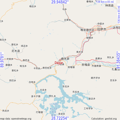
Dagar GPS coordinates[2]
29° 20' 14.352" North, 90° 40' 52.392" East
| Map corner | latitude | longitude |
|---|---|---|
| Upper-left | 29.94842°, | 89.9781° |
| Center: | 29.33732°, | 90.68122° |
| Lower-right: | 28.72254°, | 91.38435° |
| Map W x H: | 136.3×136.3 km | = 84.7×84.7mi |
| max Lat: | 53.31946° ⇑61.5% North |
| Dagar: | 29.33732° |
| min Lat: | ⇓38.5% South 18.22056° |
| min Long | Dagar | max Long |
| 75.07348° | 90.68122° | 134.28917° |
| W 3%⇐ | ⇒97% E |
Elevation
Elevation of Dagar is 3598 m = 11804 ft, and this is 3113.2 m = 10214 ft above average elevation for this country.
| Max E: |
5622 m = 18445 ft | 2.1% |
| Dagar | 3598 m 11804 ft | |
| Avg. | 484.8 m = 1591 ft | |
Min E: |
-3 m = -10 ft | 97.9% |
See also: China elevation on elevation.city.
Geographical zone
Dagar is located in North temperate zone (between Tropic of Cancer and the Arctic Circle). Distance of this Northern Tropic circle is 656.1 km =407.7 mi to South.| Distance of | km | miles | from Dagar |
|---|---|---|---|
| North Pole | 6745.1 | 4191.2 | to North |
| Arctic Circle | 4139.2 | 2572 | to North |
| Tropic Cancer | 656.1 | 407.7 | to South |
| Equator | 3262 | 2026.9 | to South |


Nearby cities:
15 places around Dagar: (largest is in red/bold)
• Caina
28.8 km =17.9 mi,  66°
66°
• Dongla
29.9 km =18.6 mi,  167°
167°
• Gongbuxue
62.9 km =39.1 mi,  149°
149°
• Jibenggang
56 km =34.8 mi,  50°
50°
• Kangxung
58.3 km =36.2 mi,  264°
264°
• Karlung
38.5 km =23.9 mi,  209°
209°
• Karru
56.9 km =35.4 mi,  271°
271°
• Konggar
30 km =18.6 mi,  99°
99°
• Lhasa
53.4 km =33.2 mi, 49°
• Nam
28.1 km =17.5 mi,  58°
58°
• Niu
42.4 km =26.3 mi, 52°
• Partang
42.1 km =26.2 mi, 261°
• Pusum
54.5 km =33.9 mi,  289°
289°
• Ramba
58.4 km =36.3 mi,  246°
246°
• Xumai
43 km =26.7 mi, 289°
Sources, notices
• [Note1] Compared only with cities in China existing in our database
• [Src1] Map data: © OpenStreetMap contributors (CC-BY-SA)
• [Src2] Other city data from geonames.org with taken over terms of usage.
• [Src3] Geographical zone / Annual Mean Temperature by Robert A. Rohde @ Wikipedia
